A YELLOW, TORPEDO-SHAPED VESSEL the size of a dolphin journeys toward the sea floor. It cruises along, taking nearly 100 measurements per second in the deep waters of Monterey Bay canyon. Then a low-power warning beeps and the crewless vessel, named Dorado, heads for home: a rendezvous point on the surface, scanned by nervous researchers who wait to see whether their prized possession will return in one piece. |
||
Exploring on their own, robotic submarines unlock the secrets beneath the waves and ice of our oceans. |
They’re anxious because their invention is out there entirely on its own. "Dorado is making the decisions it needs to make, because when it is underwater, it’s completely out of communication with us," explains James Bellingham, director of engineering at the Monterey Bay Aquarium Research Institute, or MBARI, in California. Dorado represents a unique new class of free ranging, untethered robot submarines called Autonomous Underwater Vehicles, or AUVs. The MBARI invention roams the cracks and crevices of the bay’s canyon much like a traffic helicopter, dipping and diving to take stock of forces shaping life in the marine sanctuary. Just as a surfer can feel a cold current passing by her toes, the small ship senses what flows beneath the ocean surface: glowing marine microbes, poisonous blooms of algae, and rolling underwater waves. By gliding through the seas, AUVs are giving scientists an extraordinary new view of the ocean. The robot submarines can track oceanic events unfolding over a range of depths. They can survey a whole square kilometer of the ocean in just a few hours–a richness of detail impossible to obtain from traditional surface research vessels or by towing underwater vehicles behind ships. AUVs easily explore below polar ice or operate in high seas, opening a window on truly uncharted territory. Researchers are now using the unique traveling abilities of these vessels to answer questions on everything from global climate change to sea floor tectonics. In the quest to build these versatile underwater explorers, MBARI and the Woods Hole Oceanographic Institution, in Massachusetts, are leading the way. "The ocean is terribly understudied. You can look in one spot in the ocean and things might be very different if you just move over one kilometer," says Bellingham. "In that way, the ocean is so much more difficult to track than the atmosphere, unless you dip something into it." Dorado is MBARI’s dipper. It can continuously monitor and record the temperature, saltiness, pressure, and light levels of the water it swims through. It also sends out sonar to identify the ocean floor below, a looming cliff of rock, or even ice overhead. Researchers reconstruct thousands of bits of collected data into a three-dimensional picture of the ocean. That picture might reveal sediments wafting up from the bottom, warm and cool waters mixing to melt Arctic ice, or vast clouds of microscopic marine organisms, called plankton. No video camera can capture the information in these pictures, Bellingham says. Video footage might uncover fantastical unknown deep-sea creatures, but it doesn’t record the temperature of their environs, nor can it count how many animals live in a given area of the ocean. MBARI engineers named their robot submarine after the Dorado dolphinfish, hoping it would be "free-ranging, slick, and speedy" like its biological counterparts, says Drew Gashler, one of the AUV engineers. Suntanned and pony-tailed, Gashler works in the AUV lab, which was recently added to MBARI’s beachfront complex at the midpoint of Monterey Bay. The lab is a workshop filled with scattered wrenches and pliers, plastic vehicle casings, spools of colored electrical wire, and several laptop computers. Next to the lab, a saltwater test tank 11 meters deep waits to try out the oversized bathtub toys. Through two large bay doors, the lab opens to the dock where Dorado’s support ship, the Zephyr, a retired 26-foot pilot vessel, is moored. "Dorado comes in chunks, just like Legos," says Gashler. Modular by design, the sturdy plastic vehicle has a pointed nose cone and a tapered tail cone that ends with a blue plastic propeller. These two pieces directly snap together, or can also take on one or two middle sections in between that hold multiple scientific tool packages. "You can operate it on Monday for Billy Biologist and on Tuesday, you can operate it for Jimmy Geologist," Gashler says. With all pieces assembled, the vehicle stretches 5.5 meters long and half a meter wide–about the size of two dolphins, end to end. Gashler opens the tail section to reveal the vehicle’s guts: its computer brain, a hard drive for storing data, motion sensors that detect pitching and rolling, and the propeller motors. The sensitive electronics are housed under a glass bell that keeps water out and resists pressure up to 6,000 meters deep. Once Dorado submerges, other sensors record the properties of the seawater that floods its compartments. Designing Dorado to navigate by itself proved tough. Navigating by global positioning satellites or dead reckoning only works at the ocean’s surface. Dorado instead calculates its underwater position by listening for pings from sonar transponders scattered in known locations, and uses gravity sensors to tell which way is up. Its propeller acts as a three-in-one tool: It propels by spinning, acts a rudder by moving left and right, and controls depth by moving up and down. Dorado might follow a programmed path at a certain depth or skim along at a certain height above the bottom, tracing the terrain with its sonar. As the robot submarine sails along, its brain receives feedback from navigation and motion sensors so that the vehicle can dodge hazards or stay on course. If something goes wrong, computer programming gives Dorado enough smarts to finish its mission, or at least reach the surface safely. Coastal environments are full of hazards such as steeply rising shelf bottoms, piers, and ship traffic. Ensuring that an AUV comes back with its data is critical. Otherwise, says Bellingham, "your entire career is sitting on the bottom of the ocean and all you have left is an embarrassing story to tell your buddies around beer drinking." It takes only two people on a small boat to launch Dorado on its way to record a slew of data. On a typical route, it travels along in one direction, but oscillates up and down from the surface to 60 meters below. When finished, it pops to the surface and signals, "I’m done," via a radio modem. Once it’s back on board, scientists simply plug into the AUV and download enough data to keep them busy for the next several months.
JOHN RYAN, A PHYSICAL OCEANOGRAPHER at MBARI, has chomped through AUV data for the last year and a half. He studies how physical structures and properties of the ocean change where marine lifeforms appear. "We get a 3-D view as the AUV zigzags back and forth and yo-yos up and down to sample the whole region," says Ryan, pointing to a series of rainbow-colored cross-sections of the ocean on his computer screen. Each slice is a snapshot of the sea that he created using data collected by Dorado. The colors represent gradients of the water’s properties, just like colors on a weather map show the gradient of temperatures across the country. By overlaying the slices in a composite, Ryan can see all of the dynamics in that segment of the ocean. Using this technique, Ryan is studying how blooms, or growth spurts, of tiny single-celled algae are born. The blooms are important because they can dictate the feeding patterns of fish, which in turn become food for larger fish and sea creatures. Thus, the algae can influence the ocean’s whole food chain. Sometimes, for instance, growths of toxic algae introduce a poison that works it way up to the top of the food chain, potentially harming marine mammals, birds, and even humans. In August 2000, Ryan used Dorado to map an algal bloom in Monterey Bay. To monitor the growth, he attached a special light-reflecting sensor to Dorado. The sensor detects a specific shade of green light reflected by chlorophyll pigments found in the marine organisms. From these measurements, he mapped the bloom to a subsurface layer 5 to10 meters thick. Another sensor, meanwhile, sends out red light and then records how much is reflected back by particles suspended in the water. When Ryan overlaid the cross-sections recorded by the two sensors, he clearly saw the cause of the bloom. The slice from the red-light detector revealed the same subsurface layer of algae, but also showed sediments coming up from the ocean bottom. Ryan speculates that these sediments contain nutrients that feed the algae–a process scientists had assumed was happening, but had never witnessed before now. The sediments might also trigger blooms by bringing dormant algae spores to the warm, sunlit surface, he says. What’s more, says Ryan, the water carrying the sediments is very cold. That means it came from deep within Monterey canyon in a coastal process called upwelling, in which water from the bottom of the ocean rises up to replace water blown out to sea by winds. This year, Ryan hopes to use Dorado to determine whether upwelling is a constant influence on algae growth in the bay. "We caught a glimpse of a process that may be there all the time and have a persistent effect on the ecology of the bay. Now we can go back out there and look at it again with the same technology," he says. "Ultimately, we want to be able to predict what conditions are likely to result in a bloom." While Ryan used the AUV during summer days, another MBARI oceanographer, Steve Haddock, took it "night swimming." Haddock studies the distribution of glowing, bioluminescent plankton in the ocean. Besides the wondrous phosphorescent beauty that these organisms bring to the sea, they also give scientists a way of measuring the living particles at the base of the marine food chain. Just as photosynthesizing plants support the terrestrial food chain, one kind of photosynthesizing algae, called phytoplankton, keep the ocean ecosystem healthy. Haddock hopes to predict the abundance of the plankton from the blue-green light that many of them give off. To measure bioluminescence, Dorado uses a device called a bathyphotometer, a cylinder the size of a paper towel roll that sucks up a water sample and stirs it around to stimulate any plankton inside to shine. The device amplifies and records the tiny sparkles of light. "Inside the bay, we are trying to predict from circulation patterns where these lumps of ocean that have high bioluminescence came from," Haddock says. His slice of ocean from Dorado’s data showed glowing plankton in the upper 30 meters of water. The organisms drop off sharply and disappear at about 12 kilometers offshore. This tells Haddock that the plankton feeding all life in the bay stays relatively close to shore, sometimes concentrated in pockets that move very little. “We didn’t have to do anything to get this, just drop the AUV in and pick it up," Haddock says with a smile. Most oceanographers work with a view of the sea that’s like putting on a scuba mask and looking straight down below a ship, he says. If they want a different view, they have to move the ship. "But the AUV gives us a way to get an entire swath," he says.
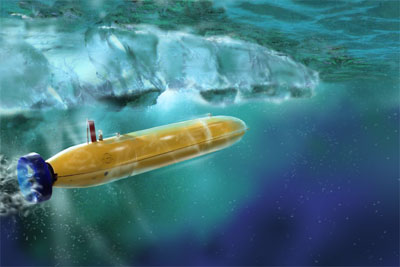
SCIENTISTS NEED A BETTER perspective of the ocean under the polar ice as well. Last October, MBARI researchers and engineers put on their parkas and climbed aboard a U.S. Coast Guard icebreaker to take their brainchild under the Arctic ice north of Norway. Their experiment was a test run for the Atlantic Layer Tracking Experiment (ALTEX), an international project to determine the fate of warm Atlantic water that enters the Arctic Ocean. Many climate researchers believe that the first effects of global warming will appear in the polar regions, as warmer waters melt away the thick ice covering the polar oceans. Before the invention of AUVs, scientists measured temperature and ice thickness of polar waters once a year from a Navy nuclear submarine traveling under the ice. But the Navy is gradually retiring its polar class of submarines. And, researchers would like to track ice thickness throughout the year. So, in collaboration with others, MBARI designed a full-length, modified version of Dorado that can swim just beneath the ice for more than 1,000 kilometers. The plastic vehicle cruises along at a much closer distance to the ice layer than a nuclear submarine can safely navigate, and returns more precise data. One particular challenge was crafting the AUV so that it could surface periodically through the ice to check in with researchers via satellite. To pull the trick off, engineers dreamed up an ingenious solution: an "ice buoy" that ejects from the ALTEX vehicle through a swinging door and rises to the underside of the ice. The device releases a lithium pellet that reacts with seawater and creates enough intense heat to burn through the ice layer. Once it pops to the surface, the buoy deploys a satellite antenna to send its data by e-mail to the scientist, reporting on ocean conditions and ice thickness. The crew of engineers began testing the AUV in the open water created by the icebreaker, keeping an eye out for polar bears. After a few short trips out and back went according to plan, they took a deep breath, gave the AUV a helping push to dive down, and sent it under the ice. After what one crew member called "the longest 15 minutes" aboard the monthlong cruise, cheers and high fives went around when they spotted the yellow vehicle in the rendezvous area. Gashler designed the test programs, which he calls the "baby steps" of ALTEX. He stresses the importance of working out bugs while still in open water. "If it doesn’t work, hold the phone, we’re going to test it again until it does," he says. Once the $500,000 vehicle goes under the ice, there’s no way to retrieve it if it breaks down. "The ocean is big and we don’t have a string attached," Gashler says. "So it’s a nerve-wracking thing because the AUV is expensive and one of a kind." For most oceanographers, however, half a million dollars looks like a steal. "From the perspective of buying a car, that looks expensive, but you have to look at the fact that an average research ship costs $20,000 to operate for one day," says Chris von Alt, an engineer at the Woods Hole Oceanographic Institution in Massachusetts. Alt and his colleagues have built robot submarines similar to Dorado, but with different talents. Their vehicles launch easily from rubber Zodiak boats, work over whole seasons for many years, and only cost a month worth of ship research days. One model is available commercially for scientists to purchase and adapt to their own research purposes. Alt wryly points out another advantage to robot subs. Recently, he and his colleagues took one of his AUVs on test runs off the New Jersey coast, with graduate students following the course of the vehicle from a ship. "The students were getting seasick, feeling miserable and cold, while we were in a warm room onshore having a good time," he says. To delve deeper into areas left unmonitored by oceanographers, WHOI engineers developed the Autonomous Benthic Explorer, or ABE. Shaped like the Star Trek Enterprise, this vehicle can glide down to 6,000 meters to levitate above the ocean bottom. Al Bradley, an ABE engineer and caretaker, explains how the 1,600-pound vehicle differs from the lightweight Dorado. "If you are flying in a light plane, you don’t dare fly into low valleys because the mountains may climb faster than you can, so you stay well above the mountains. MBARI’s vehicles are optimized for mid-water or flat areas," he says. Conversely, ABE is designed to take on the rugged terrain of geologically active seafloors, including vertical cliffs, valleys, and mountains. Instead of one main steering propeller, ABE has seven thrusters oriented to allow for movement in any direction, including reversing to travel up overhanging cliffs. WHOI oceanographers have sent the benthic explorer out to explore cooling underwater lava flows, investigate how new seafloor forms, and study how mineral deposits form in cracks near super-hot water surrounding volcanic vents. Many scientists don’t believe the data from ABE at first because they’ve never seen such a detailed view of the bottom of the sea, Bradley says. "The greatest reward to us as engineers is seeing the scientists tearing their hair out trying to figure out what to do with this data that is both exasperating and exhilarating," he says. AUVs are revolutionizing the way oceanographers observe the ocean, Bradley says. "Trying to study the bottom of the ocean from a ship is like aliens trying to discover what a football field looks like from orbit. All they see is a tiny green blob. If they use deep-sea submersibles with a video camera, it would be like seeing the species of grass and insects on the field through a galactic microscope. What you need is the helicopter that hovers and scans back and forth and gives you a survey that tells you it is a rectangle of grass with white lines on it." In other words, robot submarines give scientists a powerful way to spy on the ocean. Eventually, scientists hope to dock AUVs out at sea, where they could alert computers on shore when events such as toxic algal blooms occur. Then, with the push of a button, scientists could deploy the AUV to monitor the event, without ever getting their own feet wet. The knowledge gleaned from these free-roving ocean sentinels will reshape our understanding of marine chemistry, geology, and biology–forces that give the planet weather, continents, and life.
"The ocean is fundamentally opaque," says
MBARI’s Bellingham. "The only way to visualize it
is to introduce sensors on a platform like an AUV."
The AUV takes researchers to places they otherwise
couldn’t explore, such as the Arctic basin. "The
Arctic is the canary in the coal mine for global climate
change. The ice there is in fact warming and melting. But
is it global warming or the Arctic oscillation, a normal
climate cycle?" asks Bellingham. "You really need
an AUV to get at these problems." |
|