
The mountains of the High Sierra, the backbone of California, rise out the mist to tower over the red plain and rocky valleys below. To frontiersmen of the 19th century, these rugged mountains promised wealth and new life. To Californians, they embody state pride and a weekend's wanderings. To conservationists, they are reminders of one of the state's worst environmental sins and the need for permanent protection. To geologists, these pinnacles present yet another face: They are a riddle. After more than a century of speculation and study, no one knows how old they are.
For years, teachers have used the history of the Sierra Nevada as a classic lesson in plate tectonics. The mountains began to rise about 4 million years ago, the lesson goes. This is the prevailing wisdom, bequeathed to Californians from turn-of-the-century geologists. More recently, scientists studying the impressions carved into tilted bedrock by ancient rivers disagreed. The Sierra began ascending 20 million to 25 million years ago, they concluded.
The answer to this puzzle may lie in the awful scars left on the mountains by the gold-hungry miners known as the 49ers. Three geologic detectives from Stanford University has followed a trail of ancient raindrops to arrive at a new, much older, estimate of the Sierra Nevada's age. The researchers scoured now-defunct mining camps for clay samples that encoded the chemical signature of rain from long ago. These faint traces revealed how the altitudes of the ancient mountains changed over the millennia. The technique—tried-and-true in other settings, but never used for mountain building—says the Sierra are at least 45 million years old, nearly twice the canonical estimate.
"The major success of this study," says Andreas Mulch, lead author on the team's paper in Science, "is that it is actually a really, really simple problem we were trying to attack: How high is high?"
Roots of the mountain debate
The debate began in the wake of the Gold Rush in the mid-1800s, which bared the mountains' ancient rock to future geologists. Rivers cut like knives through the mountains millions of years ago, revealing veins of gold. Once eroded from the bedrock veins, the gold intermingled with the gravel of ancient riverbeds. As rapacious miners shattered primordial rocks in search of gold, they traced the paths of those rivers and unearthed them for the first time in millennia.
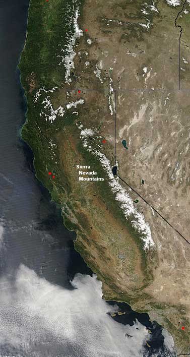
The Sierra Nevadas from space (NASA)
No matter how old they think the Sierra are, researchers agree on a few things about them. They are the product of tectonic drift. Earth's surface is made of sheets of cold rock floating, raft-like, on a layer of hotter, dense rock that flows like putty. The Sierra Nevada arose when two of those vast sheets slid past one another: the North American Plate and the Pacific Plate. The continual jostling of these slabs triggers California's ongoing earthquakes. The question is how that turbulence first occurred and when it propelled the mountains skyward.
In the 1880s Joseph Le Conte roamed the Sierra with his friend John Muir. Le Conte studied the ancient riverbeds. Based upon the way the riverbeds seemed to tilt, Le Conte declared that the mountains must have risen significantly—1,500 to 2,000 meters—in the last few million years.
This school of thought, now called the "Young Sierra" theory, still has adamant followers. They contend the mountains rose 3 million to 5 million years ago—quite recently, in geologic terms. They say the rising, or "uplift," occurred when an enormous chunk of dense rock broke off the bottom of one plate and sank into Earth's hot mantle. This lightened the plate above, allowing it to buoy up like a balloon cut free of its leaden anchor.
The first dissension arose in 1911 when geologist Waldemar Lindgren, working with the United States Geological Survey, published a map of what the ancient routes of the rivers might have been.
Stephan Graham, the expert in ancient riverbeds on the Stanford team, says Lindgren's paper began this brush fire of a debate. "Lindgren generated a bunch of maps that reconstructed the Sierra landscape. He showed there were drainage systems in the Sierra 40 or 50 million years ago that didn't look so much different from today," Graham explains. That means the mountains were far older than Le Conte thought.
Geologists who support Lindgren claim the mountains rose long ago and escaped most of the effects of erosion. They assert the modern mountains formed in a collision of mammoth proportions when part of the Pacific Plate crashed into and slid under the North American plate. The rock of the top plate had nowhere to go but up. The mountains probably rose to their modern height at least 25 million years ago, these geologists believe.
Since Lindgren's time, geologists and paleontologists have tackled this problem with every tool in their scientific kits. Some plumb the depths of gorges or study the remaining gravel, and some try to establish the age of volcanic rocks from ancient eruptions. Others use chemistry to track radioactive decay of minerals. None of these studies yielded a conclusive result; many only widened the rift between the Young Sierra and Old Sierra camps.
Silver lining of a disaster
The solution may lie in places like Malakoff Diggins State Historical Park. To a visitor unaware of its history, the landscape here possesses an otherworldly desert beauty reminiscent of Bryce Canyon in Utah. Such visitors might praise the rugged beauty of rocky cliffs reflected in the serenity of calm, green pools. The difference between the two is that millions of years of erosion sculpted the boulders and cliffs of Bryce Canyon. Malakoff Diggins is the open wound left by only a few decades of prospectors' insistent hands.
Californians have long deplored hydraulic mining as one of the state's worst environmental sins. When gold got too scarce for miners to pan for it by hand, they brought in enormous water cannons to make the job more efficient. These Howitzer-like cannons filled the hollows of the mountains with the din of a Civil War battlefield. Called "monitors" or simply "giants," the cannons shot streams of water at the sides of the mountain to shear soil and sediment away from the mountain slopes. Tons of earth tumbled down the mountains, carried by dirty, sulfurous water and awash in the toxic mercury that helped separate gold from rock. The sediment clogged rivers from the Sierra to the sea until it completely filled in their banks. The mercury still lingers in San Francisco Bay.
This scene played out all over California's gold country, but Malakoff Diggins was the largest hydraulic mine of its time. The gold ore ran thin here, petering out just 60 feet under the surface. Original miners named the place Humbug, in honor of their failure. After the water cannons arrived, though, mining became lucrative. Residents changed their town's name to the more respectable North Bloomfield.
Today the Park Service keeps North Bloomfield as a full-scale museum of a mining town, complete with general store and two of the original cannons. Also preserved is the gaping gash the miners left: 2100 meters long, 900 meters wide, and nearly 200 meters deep in places.
Even after 150 years of recovery time, the scene is appalling. The scars of the miners' attack on the mountains seem as fresh today as when the red clay ran like blood. The mountains are shorn, denuded; the huge emptiness where mountains used to be has the eerie stillness of an abandoned gravel pit. The solemn ghost of past greed hangs in the air like a palpable gloom. The air itself seems to lack scent: It's a dead smell. Milky green or white alkaline pools dot the landscape. The few stalwart trees that struggle to live here only emphasize the desolation.
Hydraulic mining is now illegal in California, but the erosion of the Sierra continues. Without trees or bedrock to anchor it, the soil continually drifts down the slopes, accumulating in the manmade chasm between the mountains.
Trailing primordial clouds
This scene proved central to the investigations by the triumvirate of Stanford scientists—Andreas Mulch, Stephan Graham, and Page Chamberlain. Mulch was a postdoctoral researcher at the time, a geologist in love with labwork and fieldwork and eager to do both at once. He worked under Chamberlain, a geochemist who used subtle chemical fingerprints to study his two disparate passions: birds and rocks. Before tracking the growth of mountains, Chamberlain used chemical clues to trace bird migrations. A poster of Roger Tory Peterson's warblers adorns his geology office.
Of the three geologists, Graham has pondered the age of the Sierra the longest. As a graduate student, he wandered the old mines, where the bones of the mountains protruded from the surface and the dusty smell of Paleolithic history filled the still air. He tried to assess the age of the mountain by looking at the weathering of large rocks that formed the riverbed of the ancient rivers. However, they were too scarred by their encounters with gold miners. He moved on to study Tibet's mountains.
But the Sierran puzzle stayed with Graham. "That had never been out of my mind," he says. "I was aware of the issues, but there weren't new methods to be applied." That changed when he met Chamberlain, who offered him an unexpected tool: isotope ratios.
Chamberlain studies the ratios of elements and their isotopes, and how and why those ratios shift. An isotope is an atom of an element that has either acquired or lost a neutron in its nucleus. This does not affect the atom's charge, but it does change its weight. Specifically, Chamberlain is interested in the isotopes of oxygen and hydrogen that exist naturally in rainwater.
Rainwater has two forms of hydrogen: the normal form, with one proton and no neutrons, and rarer deuterium, which adds a neutron. Scientists have used variations in these isotopes to track hurricanes and follow bird migrations. Chamberlain figured he could chart the growth of mountains as well as by tracing water deep into the past.
When rain clouds cross mountains, they scrape up the side and drag their bellies over the peaks. As a rain cloud ascends, it releases raindrops containing water with heavy isotopes first, then lighter isotopes at higher elevations, like a mountain climber lightening her pack for the hard climb ahead. The thirsty earth of the mountain soil catches the raindrops. In some soils, adding water transforms the clay into another mineral: kaolinite. That mineral incorporates the molecular signature of the rainwater.
The kaolinite the geologists studied came from river deposits that date back to the Eocene era, some 40 million to 50 million years ago. Scientists know how old these rocks are, but they can't be sure of their ancient altitude. The kaolinite could have formed just as easily at sea level or on top of a mountain. Only unlocking the chemical signature of its formative raindrop can reveal that secret.
Millennia ago, layers of new soil covered the raindrop-bearing kaolinite. Luckily for the geologists, the kaolinite persists in the primeval riverbed formations. These same deposits held the gold that drew miners west. The miners laid bare both gold and kaolinite again when they assaulted the Sierra with hydraulic cannons in the late 19th century. To collect kaolinite samples, the geologists simply had to go to abandoned mining camps and pick it up.
Mulch, who led the Stanford study, says the research was only possible because of the covetousness of the 49ers. "People were looking for the gold, so everyone was trying to find these particular river deposits in order to become rich and famous," Mulch says. "Without the miners who actually produced these huge environmental changes by ripping up these entire mountain ranges, we would never have had the rock that we used."
Decoding the drops
The Sierra are perfect for using raindrops to trace the face of a mountain, Graham says. Researchers know precisely where the ancient sea used to lap up against the mountains, farther inland than it is today. That's not the case with mountain ranges in more complex regions, like the Himalaya.
"The beauty of this particular place is that you know where the beach was at any particular time," Graham says. "You can walk from the beach, where the rivers entered the sea, through a bay like San Francisco that used to occupy central California, and you can walk upstream to the peaks. At the edge of the Tibetan plateau it's impossible to relate elevation back to ancient sea level."
All three scientists headed into the Sierra for camping trips, winding up narrow weather-beaten roads. They stayed four or five days at a time, collecting kaolinite from the still-raw patches on the flanks of the mountain. Back at Stanford, Mulch studied the rocks in the space age Stable Isotope Laboratory. The warehouse-like lab shines overwhelmingly with white and steel, stark colors against the rosy terra cottas and spicy remoulade oranges of the kaolinite. In here, the hum of analytical machines almost drowns out the deep bass of a stereo system in the corner, and both make conversation difficult.
Mulch heated the kaolinite samples to more than 1450°C, a temperature at which cast iron can be poured like gravy. Intense heat breaks hydrogen's bond to oxygen, baking hydrogen gas out of the sample. Then Mulch analyzed its chemical signature in a mass spectrometer. This sensitive device analyzes how much of the sample is normal hydrogen and how much is the heavier isotope, deuterium.
The team took 34 samples of ancient kaolinite and determined how much deuterium each contained. Because the scientists knew where the ancient sea level was, they could determine how much deuterium was in the raindrops that fell there. Those that fell on the seashore contained the most deuterium, because the heaviest raindrops fall on the lowest places. As the clouds traveled farther up the mountains, each raindrop contained less deuterium, on average. Using the amount of deuterium in the coastline raindrops as a baseline, they were able to project how far up the mountain each kaolinite-encased raindrop fell. Using an equation to quantify this relationship, they could pinpoint the ancient altitude of each kaolinite sample.
Comparing the composition of these ancient kaolinite samples to modern ones showed something surprising: Within margins of error, they were identical. That meant the elevation of the Sierra has not changed significantly in the last 45 million years. Because the mountains were at their current height that long ago, they must have formed even earlier, though this study cannot tell when that was.
Results and rebuttal
Some of the first reactions were squawks of indignation. The ages couldn't be right, the Young Sierra camp said, because erosion would have worn away the mountains by now. According to Mulch, they have maintained their height because the active tectonic plates lift the mountains at about the same rate that wind, weather, and water shears layers off their peaks.
Mulch says his study even may explain some of the data supporting the Young Sierra theory. The team discovered evidence for a slight uplift—about 300 to 600 meters—of the mountains 3 million to 5 million years ago. This smaller upheaval may have left red herrings for geologists to find and interpret as evidence of significant recent mountain growth.
Chamberlain says the simplicity of the study makes it almost unassailable, even though it clashes with the dogma of the Sierra as young. "The data show no evidence for a recent uplift," he says. "You're left with saying isotopes don't work [if you disagree]. That's your only option at this point. And if that's the case, we all need to get out of this business."
Geologist Craig Jones of the University of Colorado in Boulder does disagree. "My gut feeling is that there's something about the isotopic work we don't understand yet," Jones says. "Obviously there's a tendency to throw out the idea that the newest results are the correct ones."
Jones cannot find anything wrong with the Stanford results, except they contradict other geological evidence he feels supports a younger mountain range. Rainfall chemistry, or its signatures at different elevations, might have been dramatically different in an ancient climate, Jones says; he is sure some error lurks in the method. "It's very new. It has a lot of promise. It just seems right now that it's butting heads with a lot of other observations. A lot of times that's how you kind of work out the kinks."
Other ranges beckon
In spite of the simplicity of their study, the researchers worried until the results were in.
"It's a scary thing," Mulch says. "You walk up a river. The farther you walk, the higher you have to get. And in theory, it has to work. I have to admit that often times in the lab I was pretty nervous that the data wouldn't fall into place."
Mulch, Chamberlain, and Graham are now working to apply this technique to the western United States, in hopes of finding more corroborating evidence for their study. Standing in the sample room where rocks live in rows of drawers and aisles of shelves, a ragged green backpack over one shoulder, Chamberlain turns over rosy samples of kaolinite in his hand. These tiny chips of the Sierra will stay at Stanford, prepared for future study.
Whatever the true age of the Sierra, the mountains are still enigmas. Many see beauty in their mystery. And scientists find beauty in the idea that clues to their history appear by looking through the prismatic windows of raindrops.
ABOUT THE WRITER
Brittany Grayson
B.S., ecology and evolutionary biology, Purdue University
Internship: Discover.com
 My passion for science and my passion for literature have always pulled me
in opposing directions. In my search to experience the world of science
without committing myself to the life of a scientist, I sought
opportunities for adventure. I loved the remote wildness of backwoods
trails in Montana, treasured each glimpse of a marine mammal from
whale-watching boats in Massachusetts, and was stunned by the incredible
strength of sea turtles in Mexico. But what I loved most was telling
people about my experiences. I began to see that I didnt have to
sacrifice one of my passions. By choosing both, I could introduce people
to the beauty of this world, in all its scientific complexity and dazzling
detail.
My passion for science and my passion for literature have always pulled me
in opposing directions. In my search to experience the world of science
without committing myself to the life of a scientist, I sought
opportunities for adventure. I loved the remote wildness of backwoods
trails in Montana, treasured each glimpse of a marine mammal from
whale-watching boats in Massachusetts, and was stunned by the incredible
strength of sea turtles in Mexico. But what I loved most was telling
people about my experiences. I began to see that I didnt have to
sacrifice one of my passions. By choosing both, I could introduce people
to the beauty of this world, in all its scientific complexity and dazzling
detail.
ABOUT THE ILLUSTRATORS
Logan Parsons
B.S., environmental science, Western Washington University
 In my early days of high school I discovered my ability to draw things as
they were. In love with my newfound talent, I wondered how I would
integrate drawing into my life and career. I had so many other interests,
especially science and nature. When I learned about science illustration
and the program here at UCSC, it seemed a perfect fit! For six years now
this has been a distant dream, and suddenly it has become a reality. I
know that if I dont experience this program, I will spend my life
wondering what might have been. I am very excited to be here with others
with similar interests and be motivated by a collective drive to create.
In my early days of high school I discovered my ability to draw things as
they were. In love with my newfound talent, I wondered how I would
integrate drawing into my life and career. I had so many other interests,
especially science and nature. When I learned about science illustration
and the program here at UCSC, it seemed a perfect fit! For six years now
this has been a distant dream, and suddenly it has become a reality. I
know that if I dont experience this program, I will spend my life
wondering what might have been. I am very excited to be here with others
with similar interests and be motivated by a collective drive to create.
Ann Sanderson
B.S., zoology/biology, University of Toronto, Canada
 I have always enjoyed art and the natural sciences. It was no big stretch
to combine the two. However it did take many years of wavering back and
forth from art to science to realize that science illustration was in fact
a possible career choice. I have a childlike love for animals; this love
is occasionally displayed in my somewhat irritating penchant for sticking
my hand into gopher holes and catching angry lizards. I plan to put my
artistic skills to good use at Scientific American in the summer.
I have always enjoyed art and the natural sciences. It was no big stretch
to combine the two. However it did take many years of wavering back and
forth from art to science to realize that science illustration was in fact
a possible career choice. I have a childlike love for animals; this love
is occasionally displayed in my somewhat irritating penchant for sticking
my hand into gopher holes and catching angry lizards. I plan to put my
artistic skills to good use at Scientific American in the summer.