


Killer Surf!
Scientists hasten to predict and prepare for a monster wave threatening California’s coast.
By: Krista Conger
Illustrations by: Zeke Smith
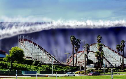
A tsunami—scientists say it could happen here—looms over the Santa Cruz boardwalk.
By anyone’s standards, the north-central coast of Papua New Guinea would qualify as a tropical paradise. White sand beaches slope gently past nodding palm trees into the blue waters of the southwestern Pacific, embracing the ocean in a subtle arc as far as the eye can see. The bright yellow sun warms the waves lapping gently at the shore. But the waters of Papua New Guinea have not always been so tranquil and inviting.
On the evening of July 17, 1998, the villagers in the town of Arop were celebrating the arrival of a three-day national holiday. Feasting was well under way on the narrow spit of land separating the open ocean from Sissano lagoon. When a magnitude 7.0 earthquake struck the area, the villagers were startled but unhurt. After all, their huts were built on stilts, capable of swaying with the shaking ground. But elders in the village were worried. Remembering native folklore, they urged the revelers to move to the other side of the lagoon, away from the ocean. Although a few people did take heed, piling into boats to cross the inland water, most people ignored the warnings.
About 10 minutes later, a loud booming noise coming from the ocean drew many people to the beach to investigate. To their horror, they saw a wall of water nearly 50 feet high rushing towards them at about 40 miles per hour. There was no escape. Within minutes, more than 2,000 people had either drowned or been killed by the force of the water and its accumulated debris. All traces of habitation between ocean and lagoon had vanished—swept bare by the scouring action of millions of tons of water. Older palm trees unable to bend with the force of the wave snapped like matchsticks. Farther inland, the water lifted sturdy buildings and moved them yards away from their concrete foundations.
The devastation at Sissano lagoon was complete. In all, three villages along about six miles of beach were nearly wiped out. Frightened survivors refused for days to descend from the highest inland hills, and demanded that visiting scientists tell them when the next wave would come. The teams of international researchers arriving to investigate the huge wave, or tsunami, could not answer their frantic questions.
Tsunamis, or tidal waves, don’t happen just in Papua New Guinea—they can occur at nearly any point along the “Ring of Fire,” the tectonically active boundaries of the Pacific Ocean. The word tsunami means “harbor wave” in Japan, a country all too familiar with the destructive power of these waves. Written records document hundreds of tsunamis that have struck the country’s coast over the centuries. Tsunami is a more scientifically accurate term than the commonly used “tidal wave,” because tsunamis are cataclysmic events unrelated to the tidal movements of normal waves.
Tsunamis are usually triggered when earthquakes move huge chunks of the ocean floor up or down, quickly displacing a massive volume of water. It’s somewhat like striking the side of a child’s plastic wading pool—the shaking of the plastic moves the water and creates a wave that can slosh over the side of the pool. But in the real world, the wading pool is the entire Pacific Ocean, and the sides of the pool are the footholds of some of the most heavily populated areas in the world.
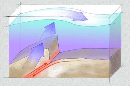
The sudden upward thrust of a rupturing subduction fault displaces massive volumes of water, spawning a giant wave.
In 1960, a magnitude 8.6 earthquake off the coast of Chile spawned a tsunami that traveled across the Pacific at more than 500 miles per hour, hitting first Hawaii and then 23 hours later, Japan. More than 1,000 people died in Chile, 61 in Hawaii, and nearly 200 in Japan. The destruction in Chile alone totaled $550 million.
Coastal towns in Washington, Oregon, and California are not immune to the threat of the unpredictable waves. Within the past century, the northern coast of California, including Santa Cruz, has been hit more than five times by the powerful waves, causing millions of dollars worth of damage and several deaths (see sidebar).
It’s a threat worth considering. A tsunami similar in height and power to the one in New Guinea would easily engulf the Santa Cruz boardwalk, submerging souvenir shops, arcades, and unwary tourists alike. The Giant Dipper, the wooden roller coaster that has thrilled adventure seekers for half a century, would be taken on a wild ride of its own as the mighty wave first toppled it, then swept it out to sea. Much of downtown Santa Cruz would be underwater within seconds.
Without an effective public warning system, the devastating property damage would seem insignificant in the face of catastrophic loss of life. To prevent this scenario, geologists, seismologists, engineers, and public planning officials have joined forces to create the National Tsunami Hazard Mitigation Project in an effort to prepare for these uncontrollable natural disasters.
Tsunami preparedness is necessarily two-pronged. First, a tsunami wave must be reliably detected in the open ocean in time for people living in threatened areas to be warned, and second, plans must exist for alerting and evacuating the affected residents. Until now, it has been fairly difficult to predict tsunamis, and frequent false alarms in Hawaii have served only to make people less responsive to the threat. But scientists at the Pacific Marine Environmental Laboratory (PMEL) based in Seattle are working to make tsunami detection more accurate.
The fact that tsunamis come in more than just one flavor complicates the scientists’ job. In the last century, the tsunamis that did the most damage to the West Coast and Hawaii were generated by earthquakes hundreds or thousands of miles away, near the Aleutian Islands in Alaska. These large underwater earthquakes spawn waves that can take several hours to reach the Lower 48. If the waves of these distantly generated tsunamis can be detected while in the open ocean, there may still be time to warn residents of low-lying coastal areas.
In contrast to their traveling cousins, the second type of tsunami is generated near the coast. As in the New Guinea tragedy, such tsunamis are caused by earthquakes just offshore and result in a wave that reaches land very quickly with no time for warning. But even for a locally generated tsunami, the New Guinea event was special. Seismologists from around the world converged on the site shortly after the tsunami to try to discover how a relatively moderate earthquake could cause such an unusually huge wave. Their understanding and reconstruction of the event may be vitally important to Californians trying to assess the risks of tsunamis along their coastline.
“The north coast of Papua New Guinea is probably the most tectonically active place in the world,” says Eric Geist, a seismologist with the United States Geological Survey. A short distance off the northern New Guinea coast, two continental plates collide, rubbing together and pushing against one another in a slow geological lambada. But based on the scientists’ calculations, even a 7.0 earthquake originating 60 miles offshore couldn’t displace enough water to fully explain the giant wave.
International teams of scientists are currently mapping the ocean floor off the New Guinea coast to determine whether the earthquake destabilized a patch of sediment, sending it sliding down a slope into deeper water. The moving land may have pushed the water ahead of it to form the wave. While this would not be the first time a landslide has been identified as a tsunami generator, it would be one of the largest and most devastating of these events.

When the ocean bottom crumbles in an underwater landslide, the moving dirt can push water in front of it and create a tsunami wave.
The landslide theory for New Guinea has disturbing implications for other parts of the world. It suggests that even a relatively small earthquake is capable of causing a huge tsunami, and that the hills and valleys of the ocean floor near a populated beach may be time bombs simply waiting for the appropriate trigger.
Some scientists think that Californians should take note. The Monterey Bay Canyon, less than a mile off the shore of Moss Landing between Santa Cruz and Monterey, has sides sloping sharply down nearly two miles. Such steep drop-offs create ample opportunities for underwater landslides. Additionally, Monterey Bay itself is bisected by two faults, the Monterey Bay fault and the San Gregorio fault.
In 1998, the California Division of Mines and Geology upgraded the San Gregorio to a Class A fault after comparing seismographic history in the region with recent movements detected along the fault line. The upgrade underscores the potential of the fault to rupture and cause an earthquake with a magnitude of 7.0 or greater. With its new classification, the San Gregorio may be on its way to join its illustrious sisters the San Andreas and Hayward faults as household names for seismically savvy California residents.
This information has scientists worried. A tsunami caused by an earthquake and subsequent landslide in Monterey Bay Canyon would occur much too quickly for a public warning system to be effective. Like the elders at the Sissano lagoon, people must take responsibility for getting themselves away from the shore after an earthquake. To help people protect themselves, scientists from the National Oceanic and Atmospheric Administration (NOAA) have teamed up with local emergency preparedness officials to create tsunami inundation maps for several coastal communities. By identifying low-lying coastal regions that are likely to flood during a local tsunami, and by mapping out safe evacuation routes in populated areas, the two groups hope to enable local residents to respond appropriately to a tsunami threat by moving away from the water even if they don’t hear an official warning. Even if people can’t get completely out of the wave’s path, “every step you take inland reduces the forces your body has to deal with,” says Eddie Bernard, director of PMEL.
In contrast to locally generated tsunamis, long-distance tsunamis offer the greatest opportunity for detection and warning before they strike land. Tsunami experts are working to perfect a deep-water monitoring system that would allow them to warn people hours in advance of an approaching wave.
Together, the two approaches may help coastal residents in Washington, Oregon, and California feel more secure. And that’s a good thing because recent scientific discoveries indicate that the chance of a disastrous tsunami slamming into the West Coast is more real than the Hollywood scenario it calls to mind.
Less than 200 miles off the shore of Washington and Oregon lies the largest active fault outside of Alaska, the Cascadia subduction zone. Stretching about 1,000 miles from Eureka, California, to Vancouver Island in Canada, it is exactly the kind of fault scientists expect to cause a tsunami. Scientists estimate that a wave generated from a Cascadia rupture would reach the shore within 20 minutes. Bruce Jaffe, a seismologist with the U.S.G.S., believes he has found evidence of a huge tsunami which devastated the northwest coast of the United States 300 years ago, as a result of a rupture in the Cascadia fault.
Jaffe studies the sediment left in the wake of a tsunami wave. He looks at cross-sections of the muck, analyzing the size of the particles in the different layers to discover how large the wave may have been. Close to the shore, where the water is moving inland quickly, the wave deposits only larger particles of dirt and debris. When the wave has lost some of its energy further inland, it leaves behind smaller grains of sand.
In a bit of geological detective work, Jaffe put together evidence from his sedimentation studies, several drowned pine forests, and local Indian legends to conclude that a massive tsunami hit Washington, Oregon, and northern California on January 27, 1700. He was able to gauge the day and time of arrival by comparing dates deduced by counting the rings of the drowned trees to written records in Japan of a large tsunami that hit its coast the same day.
While seismologists can’t predict for sure when the Cascadia subduction zone will slip again, they agree that the ruptures probably occur in 400- to 500-year cycles. If this is true, the danger to Washington, Oregon, and California has been building for the past 300 years. Evidence suggests that when the stress on the fault is finally released it could trigger an earthquake of magnitude 8 or 9.
Until now, the best indicator of an approaching tsunami has been the occurrence of a large earthquake somewhere under the Pacific. But the fundamental uncertainty as to which earthquakes may cause a tsunami and where the wave may be headed makes accurate prediction extremely difficult. Finding a tsunami is not simply a matter of watching the ocean and waiting for a large wave to pass.
The speed and height of a tsunami are proportional to the depth of water through which the wave is traveling. As the ocean bottom becomes shallower near the shore, the pull on incoming currents increases. This slows the water movement and causes the water to pile on top of itself, creating waves. But in the deep ocean, with less friction, a tsunami can travel at up to 500 miles per hour, nearly the speed of a jetliner. At the same time, the height of the wave in the open ocean can be less than three feet. A bird looking down on the ocean as a tsunami passes underneath would be unable to detect anything different from normal wave patterns, and a boat would continue to bob up and down without noticing anything amiss.
The main difference between regular ocean waves and tsunami waves is reflected in measurements of wave period and wavelength. Wave period is the time elapsing between one wave and the next as they pass a fixed point, and wavelength is the measurement of the distance between the peaks or troughs of two consecutive waves. Normal waves have periods on the order of seconds, and lengths that vary from 15 to 200 feet. Tsunami waves are much more spread out. The periods between them can be over an hour, and their wavelengths can exceed 400 miles.
The strange patterns of tsunami waves can spell disaster for the unwary. People unaware of the length of time between tsunami waves have been killed when they ventured onto the beach to clean up debris left by the first wave. “The initial wave can be small, but the second wave (hours or minutes later) can be huge,” says Rich Eisner, the regional administrator of the California Office of Emergency Services. Additionally, an unexpected drop in ocean levels is sometimes the first warning of an impending tsunami. Curious people exploring the inviting expanse of ocean bottom and coral reefs revealed by the receding water are exceptionally vulnerable when the wave strikes.
According to the laws of physics, a wave loses energy at a rate inversely proportional to its wavelength. So tsunami waves, with their long wavelengths, lose energy very slowly. That is why they can travel huge distances across the ocean and travel far up on land when they hit shore. PMEL scientists have exploited the differences in wavelength between normal waves and tsunami waves in the development of their “Deep-ocean Assessment and Reporting of Tsunamis,” or DART project.
The project is a joint effort by PMEL and NOAA to detect tsunamis when they are still far out in the ocean, giving time to warn coastal communities of incoming waves. The success of the plan hinges on sophisticated pressure recorders placed on the floor of the north Pacific which detect changes in the height of the water above the monitors. Originally developed as transportable units to accurately measure water depth when drilling for oil, the devices were modified by researchers to function as stationary recorders far beneath the waves.
The scientists plant the rectangular, box-like devices on the sea floor, sometimes as far as three miles below the ocean’s surface. A small, hollow tube filled with mineral oil provides an outlet to the sea. The tube connects to a sophisticated mechanism that resembles a curled party noisemaker at a child’s birthday party. Just as the noisemaker’s paper tube extends when one blows into its mouthpiece, the increase in ocean pressure caused by the passage of a wave overhead unfurls a piece of curved metal in the mechanism. But unlike the party favor, the metal cannot straighten completely because its curled tip is anchored to a solid support by a thin quartz crystal.
The crystal serves as a translator, converting increased water pressure into numerical measurements that scientists can analyze. It accomplishes this task by vibrating in response to a constant electric current. When external pressure increases, the metal tube tugs against the solid support in its attempts to unfurl, stretching the crystal from end to end. Like a tightening guitar string, the vibrational frequency of the crystal increases as it is stretched. The corresponding passage of a tsunami trough reduces the pressure and decreases the vibrational frequency of the quartz. The detector monitors these changes in frequency, and transmits the data acoustically through the water to a buoy on the ocean surface. The buoy then beams the information to a satellite and on to tsunami warning centers in Washington and Alaska.
As one might expect, the differences in water pressure between wave peaks and troughs are nearly infinitesimal miles beneath the surface. But according to Eddie Bernard, the recorders can detect pressure changes as small as one part per million, making them extremely sensitive.
The detectors report the normal pressure changes caused by everyday waves every 15 minutes, and the surface buoy beams the information to the satellite once an hour. But if the pressure differences are separated by more time than expected for a normal wave, indicating the characteristic long wavelength of a tsunami, the detector breaks its pattern to signal to the buoy immediately, and continues signaling every 15 seconds.
In preliminary tests, the detectors have worked well. While testing one of the first prototypes in 1988, the researchers were able to detect a tsunami wave that was only a few millimeters high in the open ocean, demonstrating the detector’s potential usefulness and accuracy. But it has taken 10 years to begin to overcome the technical difficulties of keeping the sensitive instruments functional in the hostile ocean environment. Frequent lapses in transmission remain unexplained; they may be the result of acoustical interference in conversation between detector and buoy. Physical hazards exist in the open ocean as well. On Christmas morning 1998, a ship struck the buoy of the team’s most successful prototype so far and destroyed it. “We test them in the lab, but it’s not the same as putting them in the ocean,” says Hugh Milburn, an engineer involved in the project. “We learned that the hard way.”
Although team members have had difficulty making the detectors reliable enough for use far from shore, their prospects are brightening. They have redesigned the signaling mechanism to be less sensitive to acoustical interference and are hopeful that this will make the detection system more robust. They have also included back-up acoustic signalers, just in case.
In October 1999, the researchers plan to replace the damaged buoy and plant six more new ones off the coasts of Washington and Oregon. This spring, the team also plans to begin testing a detector in the deep waters of the Monterey Bay Canyon. Milburn explains that the proximity of such deep water so close to shore will make it easy to monitor and check on the detector. Additionally, the San Gregorio fault running under Monterey Bay, as well as the steep canyon sides, make it a potential tsunami site and a practical place to test the equipment, Milburn says.
Even if the DART project is successful, simply predicting a coming tsunami is useless unless people know how to respond to the threat. Most people don’t realize the potential dangers of the big waves. “Human memory is short,” says David Oppenheimer, a seismologist with the U.S.G.S. “Santa Cruz really got whacked in the 1964 tsunami.” And yet hundreds of Santa Cruz residents lined the beaches and boardwalk in 1986 when officials issued a tsunami warning after an earthquake in the Aleutian Islands. The warning was called off and no local damage was reported, but the event highlighted public misconceptions about the large waves.
“It’s a very big but not well understood risk,” says Rich Eisner. Eisner is working with the National Tsunami Hazard Mitigation Program and Costas Synolakis, a civil engineer at the University of Southern California, to design “Tsunami Inundation Maps” for regions of the California coastline. Synolakis is using sophisticated computer programs to map which coastal areas and portions of communities may be flooded during tsunamis of varying sizes. Eisner and the National Tsunami Hazard Mitigation Program will use the data to plan evacuation routes for local residents. Eventually they plan to produce maps for the entire California coast.
Within the next year, says Eisner, signs will be posted on local beaches warning people to immediately move away from the water to higher ground whenever they feel an earthquake. Other warning signals include a sudden withdrawing of the ocean levels to below the low tide mark, or a roaring noise coming from the ocean as debris picked up by a wave is pushed along the ocean bottom. Signs explaining the danger are already springing up on the Washington and Oregon coastline.
Officials hope that the signs will educate coastal residents in time to prepare them for the next tsunami. But while they want people to be prepared, they don’t want them to panic. “Tsunamis are only hazardous to you if you live in a low-lying area along the coast,” says David Oppenheimer.
So although it’s not worth lying awake at night worrying about being swept away by a giant wave, it might pay to be prudent. The Santa Cruz boardwalk may not look at all like a South Sea island, but ignoring the signs of a potential tsunami can be as deadly here as it was in New Guinea.
Director of PMEL Eddie Bernard agrees that preparedness is better than panic. “A tsunami is going to happen, but it doesn’t have to be a disaster,” he says. Reflecting on the terrible loss of life in Papua New Guinea, he says, “We don’t want to be telling these kinds of stories about our own coastline.”
![]() 1896: An
earthquake off the Japanese coast triggered a 10-foot high tsunami in
Santa Cruz. No tsunami-related deaths reported.
1896: An
earthquake off the Japanese coast triggered a 10-foot high tsunami in
Santa Cruz. No tsunami-related deaths reported.
![]() 1906: The
great San Francisco earthquake, magnitude approximately 8.3, caused a
small tsunami, as measured by local tide gauges. No tsunami-related
deaths reported.
1906: The
great San Francisco earthquake, magnitude approximately 8.3, caused a
small tsunami, as measured by local tide gauges. No tsunami-related
deaths reported.
![]() 1946: A
7.4 magnitude earthquake off the Aleutian Islands in Alaska generated
a 15-foot high tsunami in Santa Cruz. The wave swept a man walking on
Cowell Beach out to sea where he drowned. The same earthquake caused
a tsunami in Hawaii that killed 173 people. This destructive tsunami
was the incentive for the development of the Pacific Tsunami Warning
Center. Since 1946 the center has issued 20 tsunami warnings, five of
which correctly predicted Pacific-wide tsunamis.
1946: A
7.4 magnitude earthquake off the Aleutian Islands in Alaska generated
a 15-foot high tsunami in Santa Cruz. The wave swept a man walking on
Cowell Beach out to sea where he drowned. The same earthquake caused
a tsunami in Hawaii that killed 173 people. This destructive tsunami
was the incentive for the development of the Pacific Tsunami Warning
Center. Since 1946 the center has issued 20 tsunami warnings, five of
which correctly predicted Pacific-wide tsunamis.
![]() 1964: The
8.4 magnitude “Good Friday” earthquake in Prince William Sound
spawned a deadly wave which killed 115 people in Alaska before moving
down the Pacific coast. This event was the most recent Pacific-wide
tsunami. Four people were killed on a beach in Oregon, and 11 people
were killed in Crescent City, California. Crescent City suffered
seven million dollars in damage due to the 30-foot wave. All told,
the 1964 earthquake caused ten million dollars in damage along the
California coast.
1964: The
8.4 magnitude “Good Friday” earthquake in Prince William Sound
spawned a deadly wave which killed 115 people in Alaska before moving
down the Pacific coast. This event was the most recent Pacific-wide
tsunami. Four people were killed on a beach in Oregon, and 11 people
were killed in Crescent City, California. Crescent City suffered
seven million dollars in damage due to the 30-foot wave. All told,
the 1964 earthquake caused ten million dollars in damage along the
California coast.
![]() 1986: A
tsunami warning was posted for the West Coast in response to a series
of earthquakes in the Aleutian Islands ranging in magnitude from 4.4
to 7.7. Wave height reached 10 feet in Hawaii, but only a few inches
in Santa Cruz.
1986: A
tsunami warning was posted for the West Coast in response to a series
of earthquakes in the Aleutian Islands ranging in magnitude from 4.4
to 7.7. Wave height reached 10 feet in Hawaii, but only a few inches
in Santa Cruz.
![]() 1989: The
magnitude 7.1 Loma Prieta earthquake generated a small local tsunami
along the Pacific coast. Water levels in Monterey Bay rose between
one and four feet after the earthquake. Water continued to slosh back
and forth in the Bay for at least a day, rising and falling by as
much as a foot each cycle. An underwater landslide of a two-by-five
mile section of the Monterey Bay Canyon wall was also recorded after
the quake.
1989: The
magnitude 7.1 Loma Prieta earthquake generated a small local tsunami
along the Pacific coast. Water levels in Monterey Bay rose between
one and four feet after the earthquake. Water continued to slosh back
and forth in the Bay for at least a day, rising and falling by as
much as a foot each cycle. An underwater landslide of a two-by-five
mile section of the Monterey Bay Canyon wall was also recorded after
the quake.
![]() 1992: A
7.2 earthquake off the coast of Humboldt County in California
produced a small tsunami about one to three feet high. The quake
occurred at the southern boundary of the Cascadia zone, and was the
first well-documented California example of a subduction zone
earthquake resulting in a tsunami.
1992: A
7.2 earthquake off the coast of Humboldt County in California
produced a small tsunami about one to three feet high. The quake
occurred at the southern boundary of the Cascadia zone, and was the
first well-documented California example of a subduction zone
earthquake resulting in a tsunami.
![]() 1994: A
tsunami warning was issued for Santa Cruz and the rest of the West
Coast in response to a magnitude 7.9 earthquake off the coast of
Japan. The warning was called off when the waves reaching Santa Cruz
were less than 12 inches high. However, huge waves were recorded in
the Kuril Islands off Russia.
1994: A
tsunami warning was issued for Santa Cruz and the rest of the West
Coast in response to a magnitude 7.9 earthquake off the coast of
Japan. The warning was called off when the waves reaching Santa Cruz
were less than 12 inches high. However, huge waves were recorded in
the Kuril Islands off Russia.
- BIOs
- WRITER Krista Conger
- B.A., biochemistry, University of California, Berkeley; Ph.D., cancer biology, Stanford University.
Internship: postponed owing to baby.
- ILLUSTRATOR Zeke Smith
- B.A., art, UCSC, 1996.
Internship: Frank Perry Museum Services (diorama for Pacific Grove Museum of Natural History).
Text © 1999 Krista Conger
Illustrations © 1999 Zeke Smith