
|
|
|
|
|
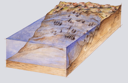
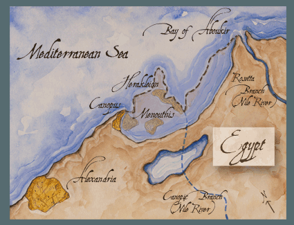
To try to learn what happened, the archeologists who discovered Menouthis last year recently called in geological experts. All geologists agree something drastic caused the ground upon which these cities were built to act like a liquid and slide almost instantly into the sea. The geologists vigorously debate why the muddy ground liquefied. One camp favors devastatingly powerful earthquakes as the culprit. The other says the inexorable deluge of the Nile in full flood caused the damage. Despite these disputes, the geologists agree that similar fates could befall coastal cities today with a much greater loss of life and property. Some archeologists argue that the ruins found at Menouthis are really part of a larger sister city called Canopus, which hosted religious festivals known throughout the ancient world for extravagance and the licentious behavior of the participants. A temple to the goddess Isis made Menouthis the religious center of ancient Egypt and destination of thousands of pilgrims. The discovery of this temple and the location of the ruins led French archeologist Franck Goddio to believe his group had located Menouthis. Nearby Herakleion stood at the mouth of the river Nile, acting as a gateway to the ports beyond. All boat traffic entering the Nile stopped to pay taxes in Herakleion.
In 1998, Goddio went looking in the Bay of Aboukir for these cities that existed only in historical writings. Armed with an x-ray-like instrument called a nuclear resonance magnetometer, Goddio and his team made a magnetic map of the floor of the bay. Trailing the magnetometer behind the boat in a pattern similar to someone mowing a lawn, the scientists detected granite columns lying beneath the sand. Since granite modifies the earth’s magnetic field differently than does the rest of the sandy bottom, the buried columns, and buildings as well, showed up as distinct patterns on the map. Goddio’s crew found two such patterned areas and made more detailed maps of them. They used an array of high-tech instruments to bounce sound waves off the bottom and paint a picture of the ground below. After mapping, divers swam down 21 feet to remove up to 5 feet of sand. They cleared one 30 by 30 foot area at a time, using a digital global positioning system to determine the exact location of each building and artifact for the archeologists’ records. Once the divers located each object and removed what they could, they uncovered the next patch of seafloor and buried the previous section. In the course of the magnetic surveys Goddio found in Menouthis a crescent-shaped crack, 115 feet long and 50 feet across at its widest point. The crack or trench was in the clayey ground of the bay, but was totally filled with sand. Scientists would later determine that people, not the sea, had filled the crack with sand. The crack sat directly below a large stone monument. Divers uncovered two other cracks as well as buildings, temples, and large fallen columns that had once lined both sides of a major street. They also found sphinxes, jugs that stored wine, sculptures, statues, and gold coins and jewelry.
Could
it be an Earthquake?
These statues reminded Goddio of fallen columns he had found during the past four years while excavating a sunken section of Alexandria, 15 miles to the west. Since geophysicist Amos Nur of Stanford University had studied fallen columns in Israel, Goddio asked for his help. Nur vividly recalls Goddio’s phone call: “I was sitting here at home. I just came back from Alexandria when Franck Goddio called me at 3:00 in the morning and said ‘Guess what? Remember when we talked about Herakleion? We just checked it out today. We removed some of the sand and we found these five statues—red granite statues—and they look like they’ve fallen in the same direction as we see in Alexandria. I think it’s an earthquake.’” Nur is convinced that an earthquake was involved in the destruction of Menouthis and Herakleion. During his previous studies in Israel along the Dead Sea Transform, the Holy Land’s version of the San Andreas Fault, Nur had seen countless Roman and Greek columns downed by a magnitude 7.0 to 7.3 earthquake in 749 A.D. Oddly, all these columns lay in the same direction. The Dead Sea Transform, like many other transverse faults involves two sections of land that slide haltingly past each other in opposite directions usually within the same horizontal plane. As the ground on each side of the Dead Sea Transform jerked past each other, columns on the west side of the Dead Sea Transform toppled northward, even as those on the east side of the fault fell southward. The consistency of these orientations with the wrenching ground motions on either side of the fault led Nur to conclude that parallel downed columns are the signature of an earthquake. The energy of an earthquake resulting from movement along a fault travels in a variety of ways. One type of motion follows the vertical undulations of a sine wave, while another involves a side-to-side shaking. The side-to-side motion leaves its mark on the architecture. As the legs of a stone arch move back and forth, the wedge-shaped keystones in the top begin to fall down. Only an earthquake could leave such a record. In Alexandria, Nur says, “There is quite a bit of evidence for tilted walls, breached arches and repaired walls.”
But how did these destroyed ancient cities end up underwater? In coastal areas, like Alexandria, earthquakes can lead to the ground falling into the water. The 1999 Kocaeli earthquake near Izmit in Turkey is one example. Whole sections of the town of Golcuk fell nearly six feet into the Mediterranean Sea. Several thousand people died because their homes sank. Residents who survived the devastating drop into the sea had to be rescued by boat from the second floor of their homes. Geologists call this downward movement of the ground “subsidence.” All scientists looking at why the Egyptian cities sank agree that at least 16 feet of sudden subsidence plunged the cities into Aboukir Bay. As divers excavate more of Herakleion in the next field season, beginning in April 2001, Nur hopes to find further evidence. If the team finds partially collapsed arches or skeletons of people crushed by falling buildings, that would lend credence to the idea that an earthquake is responsible, Nur says. In trying to determine which earthquake could be the culprit, Nur points out that more than one earthquake could have struck. “We know in the 8th century that there was a big earthquake,” he says. “There is a little bit of evidence for an earthquake in the middle of the 3rd century.” And a magnitude 6.7 to 7.0 earthquake centered off the southern coast of Crete caused widespread damage in 365 A.D. It also generated a gigantic wave, called a tsunami, that drowned thousands of people in Alexandria. There are, however, difficulties with the simple explanation that an earthquake drowned the cities. “The problem with an earthquake in Alexandria is that it isn’t near any plate boundary or known fault,” Nur says. While scientists knew other areas around the Mediterranean—Italy, Greece, Turkey and the Middle Eastern countries—were susceptible to earthquakes, they thought Alexandria was safe. “It is a challenge. Where is the plate boundary?” Nur asks.
Since transform faults often have some vertical displacement along them, ground on one side of the fault could drop several feet during an earthquake. Nur says however, that such vertical faulting probably isn’t the sole culprit in the cities’ demise. Subsidence triggered by other processes probably accompanied vertical movement along a fault. Slumping, the movement that dumps hillsides into the sea or across roads during bad rainstorms, was likely involved, he says. And liquefaction—the process by which sandy or silty soil turns to soupy quicksand when shaken—must have occurred, Nur says. Liquefaction stems from a buildup of water pressure in the spaces between grains of sand or silt. Like marbles in a bag, grains of sand have air spaces around them, even when the grains are packed tightly. In sands near the coast, water often replaces the air, though the grains of sand still touch. If enough water squeezes in between the sand grains, they will no longer touch each other. With one small push, everything starts moving: what once felt like land acts just like a liquid. Field geologist and earthquake consultant William Lettis agrees with Nur that liquefaction and slumping occurred. However, he questions the faults that Nur proposes. For example, he sees no signs of an east-west fault in the Mediterranean along the North African coast. Many episodes of faulting with huge motions along the fault would be necessary to produce the subsidence the archeologists see, Lettis says. “That amount of offset will be preserved in the landscape for thousands of years,” he says. “There is no evidence whatsoever of any fault producing that magnitude of offset.” Further, global positioning system (GPS) data show that the land on either side of Nur’s proposed second fault is moving at the same rate in almost exactly the same direction instead of at different rates. For those reasons, Lettis does not think an earthquake could have occurred near Aboukir Bay. He’s not willing, however, to let earthquakes off the hook. He says that large, long-lasting earthquakes some distance from a site could set up the right kind of conditions to cause liquefaction of soils far from the earthquake’s epicenter. “You need many, many cycles of ground shaking, on the order of tens of seconds to minutes, to get liquefaction,” he says. A magnitude 9 earthquake along the well-known subduction zone south of Cyprus, or a magnitude 7.5 to 8 earthquake along the Dead Sea fault, could cause liquefaction in the Bay of Aboukir, Lettis says. Both quakes have occurred in the past.
Could
a Flood be the Culprit?
He suspects that the strong currents of a river in full flood caused the devastation in the Bay of Aboukir. Based on evidence in the sand and silt of the Nile delta and records of the height of the Nile River, Stanley believes that heavy flooding in 741 and 742 A.D. caused the ground to fail. Egyptian landlords kept accurate records of the Nile’s height in Cairo; the water level determined the size of a farmer’s harvest and, consequently, how much of a tax the landlord could exact. These records show either one or two floods in 741 and 742 A.D., right after the 740 date of the latest coins found in Menouthis. When rivers flood, Stanley says, the velocity of the water can double. That allows the river to carry six times as much sand and silt. The tumbling and turbulent waters laden with abrasive sediments scour the channel. Add the extra weight of the floodwaters heavy with sediment, and the soil beneath can fail, Stanley says. “It takes very little to trigger liquefaction under these circumstances,” he says. During flood times, rivers can change course by abandoning previous channels and forging new ones. Data show that the Canopic branch of the Nile, which flowed next to Herakleion, has moved eastward over the past thousand years. Today no channel of the Nile flows into the Mediterranean through the Bay of Aboukir. Stanley says he thinks the 741 and 742 floods could have helped shift the course of the Nile.
The three cracks divers found in Menouthis provide another clue supporting the flooding theory, Stanley says. From observations made while diving on one of the cracks, he believes these are crown cracks, a common feature found in deltas around the world. Due to unstable ground beneath the surface, a relatively small section of the delta caves in on itself causing blocks on the surface to sink down. Crown cracks form along the edges of the collapsed depression. “We are finding these cracks and trenches exactly where we are finding architectural remains,” Goddio says of the cracks in Aboukir Bay. “Where there are no architectural remains the land is flat and undamaged, which goes well with what Professor Stanley is saying here.” Stanley says the weight of the buildings could have contributed to the growth of the cracks, but more fieldwork is needed to be sure. Stanley sees evidence of another process common at the river mouths of some deltas: cone-shaped structures called mud diapirs. From the data he’s collected, Stanley notices that deep layers of buoyant mud have squeezed their way up to the surface, much like a mud volcano under the ground. These diapirs are made of soft, mushy mud, which cannot hold the weight of a stone building. At least one diapir flowed upward under a temple and likely caused the ground to fail, Stanley says. Since the disrupted layers of sediments occur just under the temple in Menouthis, Stanley says he does not think a fault is involved. “Earthquake faults aren’t that site specific,” he says. Stanley claims he’s found undisputed signs of liquefaction. He uses a technique called carbon-14 dating to determine the age of plant remains trapped in Menouthis’s foundational muds. Under normal conditions mud gets progressively older as scientists dig down through each layer, since the most recently deposited goo sits on top. However, surface samples collected near the temple in Menouthis show muds 2000 years old jumbled together with muds 6000 years old. In some places, the older mud was on top—a clear sign the whole lot had been overturned and stirred up. Stanley was surprised to see such a wide range of ages. “One might expect to have a couple of hundred years represented, not thousands of years,” he says.
When he goes back to Aboukir this spring, Stanley plans to take many mud samples called cores. He’ll look to see which areas have normal, flat layering, and which have a jumbled hodge-podge of layers. And he’ll date the layers to see how old they are. Just as the most recent coins found in Menouthis tell archeologists that it was still standing in 740 A.D., the youngest layer Stanley can date will tell him when the liquefaction occurred. Dead plants and animals from microscopic plankton to thumb-sized mollusks can also help piece together the history of the delta. If his samples from the bottom of the bay contain plants and animals that live in freshwater, he will know the muds came from the river. If the flora and fauna are the kind that live in salt water, that slice of sediment came from the bay itself. Using these clues, Stanley hopes to reconstruct a picture of ancient Aboukir Bay that makes sense. Nur welcomes any information that will help to nail down the date of the subsidence to see if it corresponds to the three known earthquakes during the first millennium: one around 250 A.D., the 365 quake and one around 790 A.D. Goddio, too, eagerly awaits the results from the field season. Scientists won’t be able to tell which theory makes the most sense until more work is done, he says. The truth may lie in a combination of the two theories, he adds. Scientists cannot completely rule out the possibility that a tsunami or an underwater landslide triggered by an earthquake sank the cities, though it appears those causes are less likely than flooding or an earthquake. Whichever theory proves true, scientists recognize that three thriving cities suddenly fell into the sea. They predict it will happen again. “Alexandria is definitely going to be hit by an earthquake in the future,” Nur says.
The world’s heavily populated major deltas include the Nile, the Yangtze, and the Ganges-Bramaputra deltas, which combined have over 200 million people living on them. They could be prone to major catastrophes, Stanley says. “Any place that you build on soft, water-rich mud, you’re in trouble,” he says. “It doesn’t take much of a trigger. You can have earthquakes, and you can have other phenomena as simple as having a week or two of rain. Look at the critical situation of Venice.” William Lettis points out that “Golcuk was on a little, tiny creek that built its own delta. They don’t have to be the big, mammoth river deltas like the Nile” for failure to occur. Hundreds of cities could be at risk, he says, since such a large portion of the world’s population lives at river mouths. These patterns, however, no longer surprise geologists. “There seems to be a rough relationship between population density and earthquake risk. It’s as if people are attracted to earthquake prone areas,” Nur says. “Actually, when you think about it, it makes a lot of sense.” People need water, low places to build ports, and valleys to build roads through mountains. The same tectonic forces that cause earthquakes control these factors. And “valleys are the places where agriculture could flourish,” Nur says. Bare necessities aside, people are attracted to the natural beauty of tectonically active areas with their soaring mountain ranges and dramatic coastlines. While people who live in areas prone to natural disasters are aware that a catastrophe could hit at any time, they forget about the risk if a disaster hasn’t struck recently, Nur says. This selective memory loss, combined with the relentless march of population growth, which forces more and more people to live in vulnerable areas, makes for a bad situation. If a Herakleion-sized event struck Tokyo or Bangladesh today, it could kill tens of thousands of people. It’s only a matter of time before mud and water claim another coastal city.
|
|
M.S. civil engineering, focus on renewable energy, University of Colorado, Boulder Internship: Woods Hole Oceanographic Institution, Dive and Discover Galapagos Expedition Website Internship: pending
Illustrations © 2001 Brian Maebius |
 |
 |
 |
 |
 |
|
|
|
|
 |
 |
 |
 |
 |
 |
|
|
|
|
||||
 |
 |
 |
 |
||||||||||
 |
 |
 |
|
||||||||||
ContentsPage | Back to Top | Contact Info. | Science Notes Home

 The
coins were a key piece of evidence that Menouthis sank quickly. People
experiencing gradual ground settling don’t leaveprecious gold coins
lying around, Goddio says. The catastrophe that destroyed and sank Menouthis
must have occurred sometime soon after 740 A.D., since divers found no
coins minted after this date.
The
coins were a key piece of evidence that Menouthis sank quickly. People
experiencing gradual ground settling don’t leaveprecious gold coins
lying around, Goddio says. The catastrophe that destroyed and sank Menouthis
must have occurred sometime soon after 740 A.D., since divers found no
coins minted after this date. 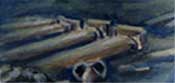 Even
beneath the waves, repaired walls survive in Menouthis, showing that it
was rebuilt at least once before its final demise in the 8th century.
Divers found at least 50 columns about 20 feet tall and 2.5 feet in diameter,
all lying toward the south-southwest. This evidence, along with a row
of collapsed columns along the half-mile stretch of ancient Alexandria’s
main road still on land, are proof that earthquakes have hit Alexandria
repeatedly in the past, Nur says.
Even
beneath the waves, repaired walls survive in Menouthis, showing that it
was rebuilt at least once before its final demise in the 8th century.
Divers found at least 50 columns about 20 feet tall and 2.5 feet in diameter,
all lying toward the south-southwest. This evidence, along with a row
of collapsed columns along the half-mile stretch of ancient Alexandria’s
main road still on land, are proof that earthquakes have hit Alexandria
repeatedly in the past, Nur says. 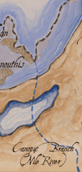 During
flood times, rivers can change course by abandoning previous channels
and forging new ones. Data show that the Canopic branch of the Nile, which
flowed next to Herakleion, has moved eastward over the past thousand years.
Today no channel of the Nile flows into the Mediterranean through the
Bay of Aboukir. Stanley says he thinks the 741 and 742 floods could have
helped shift the course of the Nile.
During
flood times, rivers can change course by abandoning previous channels
and forging new ones. Data show that the Canopic branch of the Nile, which
flowed next to Herakleion, has moved eastward over the past thousand years.
Today no channel of the Nile flows into the Mediterranean through the
Bay of Aboukir. Stanley says he thinks the 741 and 742 floods could have
helped shift the course of the Nile.