 |
Oil on the Rocks
An ongoing marine census may yield new insight into the destruction wreaked by oil spills. Rachel Tompa gets her feet wet. Illustrated by Tina Fuller and Lila Rubenstein.
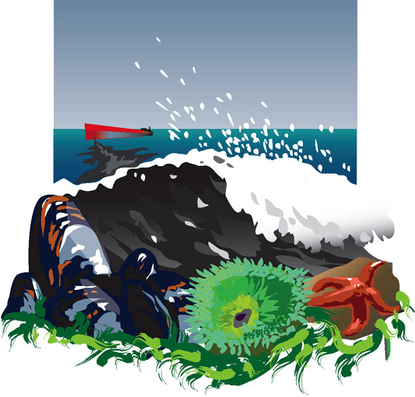
Illustration: Tina Fuller
A small black stain marks the craggy gray rock. It’s almost indistinguishable from the dark splotches of snails and algae on this rocky shore in Santa Cruz, but Christy Bell notices it. “Oh, there’s a tarball,” she says offhandedly. Flattened and hard, it looks like old gum. Soon Bell finds more streaks and globs of tar near the crumbling stairs from the road. The tarballs feel both rough and smooth, gritty with sand, but their round edges betray a liquid past. Now they are essentially asphalt, Bell says, identical to the road 20 feet away.
Many similar tarballs now dot the shores of San Francisco Bay and the surrounding coast. They were once oil on a container ship bound for South Korea. Now, instead of powering the 900-foot Cosco Busan across the Pacific, the blobs mar rocky shores inside the bay and between Half Moon Bay and Bolinas. On November 7, 2007, they spilled into the bay in a torrent of nearly 54,000 gallons of heavy fuel oil. The ship had collided with the Bay Bridge in a dense fog, ripping a giant gash in its hull.
On the grand scale of spills, this was minor. The 1989 Exxon Valdez spill in Alaska was about 200 times larger. Still, it struck sensitive habitats in a major metropolitan area, and the damage isn't yet fully known. More pools of oil might dwell on the ocean floor or behind boulders on rocky shores like this one, where Almar Avenue meets the Pacific Ocean.
Here Bell, a research technician at UC Santa Cruz, describes what she saw during the hectic days following the Cosco Busan spill. She is part of a group led by marine ecologist Pete Raimondi studying the rocky intertidal, the communities of creatures between high and low tide. Raimondi and his fellow researchers have spent nearly two decades counting organisms to gain clearer focus on the slimy world of intertidal life from Alaska to Baja, California.
This dank and dynamic ecosystem is sensitive to oil spills and other manmade catastrophes. Many intertidal citizens, such as mussels and other shellfish, are at the bottom of the marine food web and especially prone to damage. But to help the recovery, researchers must first uncover what was harmed. With their ongoing censuses, Raimondi and Bell are in a unique position to understand how oil affects the intertidal—and to advise biologists how to pick up the pieces after Cosco Busan.
In the event of an oil spill
The crash was no surprise to Raimondi. “We’d been waiting for an oil spill for the last 17 years,” he says, dating to the Exxon Valdez disaster—when nearly 11 million gallons of oil fouled Alaskan waters. While not the largest spill in history, it arguably was the most destructive, due to the tanker’s rupture in pristine Prince William Sound.
Scientists realized they might never know the extent of that spill’s damage. Secondary effects, such as the death of a starfish from eating oil-slicked mussels, are almost invisible. “The hard part of our job is trying to attribute cause and effect,” Bell says. “Sometimes it’s obvious, when a bird is soaked in oil and can’t fly.” But when small animals or microscopic critters quietly drop off the radar months or years after a spill, it’s different. And scientists did not have a good picture of communities in Prince William Sound, making it impossible to know what had disappeared.
Raimondi and his colleagues realized that if a major spill hit California, they would be no better off. Previous researchers had studied intertidal creatures, but nobody knew how many of each species lived where, and whether there were natural fluctuations. So in 1991, funded by the U.S. Minerals Management Service, they began studying the state’s coastal communities. In their ongoing monitoring, the researchers lay out grids of tape in fixed locations on the coast. They tally 13 “target species” of algae and invertebrates in the grids, visiting a few times a year. The targeted species, found up and down the coast, include mussels, barnacles, abalone, and others sensitive to oil. Back on dry land, the scientists put these numbers into a large database that tells them how many of each organism lives where, and when. They can use the database to track the rise and fall of a particular species all along the coast, or to look at all species in one spot.
The surveys yield a general picture of ecosystem health, says biologist and intertidal surveyor Mary Elaine Helix of the Minerals Management Service. “It’s like going to the doctor. You take the blood pressure, and you take the temperature—it doesn’t really tell you what’s wrong with you, but it tells you if something is wrong,” she says. Regular monitoring of an ecosystem's normal "vital signs" is important in the highly variable intertidal, where scientists must distinguish seasonal variations from death by unnatural means, such as oil spills or climate change.
Since it began, the project has grown from nine field researchers to about 100, and from nine sites in Santa Barbara County to about 100 sites between Alaska and Baja, California. This gigantic project—overseen by the Multi-Agency Rocky Intertidal Network, or MARINe, and the Partnership for Interdisciplinary Studies of Coastal Oceans, or PISCO—is peerless in age and geographic range. “The amount of time they’ve been conducting surveys out West is phenomenal,” says Jeremy Long, a researcher at Northeastern University who has started a similar project at two sites on the East Coast. “It’s absolutely essential to collect that kind of long-term data, and their program does it.”
After the November 2007 spill, Raimondi’s team visited 17 sites in San Francisco Bay and the surrounding coast to assess the spill’s immediate effects. They modified their approach to gauge the extent of oiling as quickly as possible: They took digital pictures while the oil was still fresh, instead of counting creatures on site. Later, other researchers will count the targeted species in the photos.
Not all of the current research anticipates oil spills. By keeping a finger on the shoreline’s pulse, MARINe scientists can see other changes. For example, the surveys revealed that black abalone populations were crashing in southern California (see sidebar). Raimondi’s group also monitors changes in red abalone population at Stornetta Ranch in Mendocino County, which recently became public land and is now more accessible to abalone harvesters.
However, spills are on Raimondi’s mind. Years of meticulous census-taking to prepare for a repeat of Exxon Valdez on the West Coast may seem pessimistic, but months after the Cosco Busan spill, he’s already expecting the next one: “There's so much [tanker] traffic that it just seems like a matter of time before something like this happens again."
Slimy versus sticky
It could be years before they understand the Cosco Busan spill’s long-term effects, but Raimondi and Bell have amassed clues from a previous study. The floor of the Santa Barbara Channel, which runs between mainland California and the Channel Islands, constantly leaks oil that washes ashore. “In some places down there, this part of the intertidal would be like standing on blacktop asphalt,” Bell says, gesturing at the high-tide zone.
“The intertidal is this narrow band that goes through such extreme physical conditions,” Bell says, waving her arm from the high, drier intertidal to the low intertidal zone, which right now is mostly underwater. “It’s such a dynamic area.” Different creatures adapt to different conditions in ribbons of the intertidal. From a distance, the rocky shore appears striped. The wet, low intertidal is bluish-black with mussels. Farther from the water, patches of barnacles and turf algae make a brown stripe.
Bell and Raimondi noticed that the natural oil near Santa Barbara stuck around longer on barnacles in the dry upper zone. They wondered whether the oil stuck to barnacles preferentially because of their rough surfaces, or whether the barnacles were just in the wrong place at the wrong time. Using dental molding material and Tupperware sandwich containers, Bell made plastic casts of barnacle beds and placed them in different spots in the intertidal.
Over the next 18 months, Bell checked her pseudo-barnacles for oil. She found that some species, such as rockweed, were untouched even where barnacle casts in their midst were oiled. Rockweed oozes mucus from its tips, which probably sloughs off oil. But in mussel beds close to the water, constant surf washed oil off of both casts and mussels. So the degree of oiling depends both on the texture of the affected species and external conditions in its zone. As for the barnacles, oil can cover their mouths, preventing them from feeding. “If that gets coated over, it can kill them,” Bell says. However, Bell also noticed that new barnacles sometimes settle on top of weathered tar.
Raimondi’s group saw similar variability after the Cosco Busan spill. In initial surveys they did not see much oil on slimy things such as rockweed, but they saw more on textured critters such as barnacles and some other kinds of seaweed, as well as on mussels and crabs. Where oil sticks, it hurts, but sometimes it can damage even if it doesn’t stick. Even though mussels are quickly washed clean by the surf, they are still sensitive to oil, Raimondi says. His group collected mussel and other shellfish tissue samples for analysis to determine how much toxic chemicals they absorbed from the oil. Mussels are a critical part of the whole marine community, because so many predators eat them, such as starfish, otters, and people. When they go, says Raimondi, a lot of other animals go with them.
How is a mussel not like a car?
Several of the sites Bell and Raimondi visited were not yet cleaned. “At China Cove on Angel Island,” Bell says, “you could just see it from a distance. It was like this iridescent, bluish film on the shore.” In other places, such as at Point Isabel in El Cerrito, there was thick, black oil on the rocks. “It looks different than it actually feels,” Raimondi says. “It looks like there's just hot tar on everything, meaning it almost looks liquidy. It’s shiny. But when you actually touch it, it's pretty solid. Maybe a little bit sticky, but not as sticky as you'd think.”
When oil washes up on shore, it’s important to clean it before it gets back into the water and hits birds and marine mammals. Cleanup crews can use either absorbent pads or high-pressure sprays, like those in do-it-yourself car washes. Using pads is arduous work. “They sort of pat surfaces,” Raimondi says, pretending to blot his desk with a piece of paper. “The manpower involved is astounding. There would be people out there patting the rocks, soaking it up on rags and throwing the rags away, and everyone has to wear these [special] suits. On the other hand you go in with a steamer and boooogghhhhhh,” he adds, blasting an imaginary cleaner over the piles of books, rain jackets, and towels in his office.
The pressure cleaners work so well that they can clean the intertidal to death. “It emulsifies everything,” Raimondi says. “You go through these areas and it’s just like mush.” The high-pressure spray churns up oil, sand, and rocks, launching mussels, barnacles and other creatures into the air and killing them. The mixing leaves behind an environment inhabitable for new generations of shellfish.
Studies on clam beds oiled by the Exxon Valdez spill found that it could be up to 70 years before the pressure-cleaned beds recover, compared to five to seven years for uncleaned beds. In fact, cleanup crews used pressure cleaners sparingly following the Cosco Busan spill, because of their known damaging effects. "It's looking like not cleaning at all is a pretty good option for some organisms and some habitats,” Raimondi says.
Waiting to respond
Raimondi might have seen even more oily sites had he gone out earlier. “When the oil spill occurred, I expected a call almost right away, because we were a responding group on paper to assess the rocky intertidal,” he says. “But the call didn’t come.” With some help from the U.S. National Park Service, the group finally got clearance to survey. But when they got to the sites, safety officers turned them away. By the time all the bumps were ironed out, more than three weeks had passed. "That was way longer than it should have been. It should have been six hours," Raimondi says.
Mary Elaine Helix, who was part of the incident command running the oil spill response, agrees the delay was unfortunate. She says field safety officers didn’t realize the biologists were familiar with the rocky shoreline, so their safety regulations may have been too cautious. “There was a disconnect,” Helix says. “We’ve been putting things in place so that shouldn’t happen next time.”
Oil-spill damage assessment usually comprises several steps. If researchers are quick, they can survey sites before oil even touches shore. The next step is to assess immediate damages, after oiling but before cleanup. Raimondi’s group missed step one entirely and some of step two, since some of their sites had already been cleaned. Still left are injury assessments, which could mean waiting weeks or months for the oil to do its worst, and recovery, which could take years or more.
Raimondi’s frustration is evident. “We knew the science, we knew where to go, what to do,” he says. “It was really a little bewildering to me how there was that level of miscommunication.”
How much for that barnacle?
Still, Raimondi and the other MARINe researchers are well positioned to understand how oil affects the intertidal. It’s not just an academic exercise: The data Raimondi’s group collected after the spill will help put a dollar amount on damages for a mitigation settlement. “It’s like if someone rents an apartment and they trash it and don’t pay the rent,” says Steve Hampton, resource economist with the California Department of Fish and Game. “Just having them clean the apartment is not enough. They need to also pay the lost rent.” Cosco Busan’s owner, Regal Stone, will pay damages to the intertidal’s “landlord,” the state of California, for cleanup and restoration. For example, a 6,800-gallon spill in Santa Barbara in 1997 netted a $1.9 million settlement from the responsible party.
Based on preliminary data, Hampton estimates that 50 miles of rocky intertidal were oiled by the Cosco Busan spill. “We might be hard pressed to find enough restoration for all of it,” he says. Helix is running trials to reseed decimated mussel beds with new mussels scraped off oil rigs. Raimondi thinks removing litter also might help. "When we went to these areas, even isolated shorelines and islands, there was so much trash and debris that compromised the community probably more than the oil did," he says, shaking his head. "There were engine blocks and lawn chairs. It was really astoundingly dirty."
Because of their involvement with the settlement, Bell and Raimondi are reluctant to go beyond scientific assessments. Bell says she can’t talk about her opinions on the spill. Back on the shore in Santa Cruz, when asked if it was difficult to see oil on familiar sites, she is taken aback. “That’s a hard question,” she says, and hesitates. “It’s never nice to see oil like that.” She presses her lips together and looks away.
Top
Sidebar: The Black (Abalone) Death
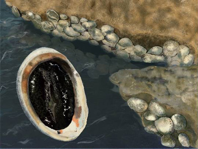 |
Illustration: Lila Rubenstein
|
Black abalone once carpeted some California and Mexico shores. Now the majestic sea snails, which occupy the low intertidal between Cabo San Lucas in Baja, California, and Mendocino County, are relegated to the odd rocky crevice. Aided by rising ocean temperatures, a persistent and deadly bacteria is slowly marching north, leaving scores of abalone dead in its wake.
Scientists with the National Park Service first noticed dwindling populations on the Channel Islands following the El Niño weather pattern of 1983–84, but the bacterial disease appeared limited to these areas. Pete Raimondi, marine ecologist at UC Santa Cruz, and fellow researchers later noticed that the disease had spread further. Between fall 1992 and spring 1993, black abalone at his research site in Santa Barbara crashed from nearly 100 to a single specimen. The shellfish fell prey to withering foot syndrome, a gut bacteria that inhibits digestion. The abalone’s “foot,” which normally protrudes from the edge of its shell, shrinks as the animal starves.
“Black abalone were so prevalent in Southern California that they were primed for a big event like this,” says Christy Bell, a research technician in Raimondi’s lab. “It’s like the plague.”
Raimondi later observed crashes spreading from south to north. By 1998, the withering plague had reached Cayucos in San Luis Obispo County. The bacteria exists in all abalone populations, although its deadly effects are hampered by colder water. Black abalone populations crashed in 1988 at Diablo Canyon in San Luis Obispo County, probably because of warm run-offs from a neighboring power plant.
Now, the U.S. Environmental Protection Agency may put the shellfish on its endangered list. Raimondi is not sure this change in status will offer more protection. Most species on the list have lost habitat because of human activity. But the abalone’s decline is not directly attributable to humans, and it's already illegal to harvest them.
Abalone offspring settle near their parents and are subject to the same diseases, so Raimondi believes biologists must take active measures to save them. Ironically, he worries that endangered status could make restoration efforts more difficult by forcing scientists to obtain permits to work with black abalone.
Top
Biographies
 Rachel Tompa Rachel Tompa
B.A. (biology) University of Chicago
Ph.D. (biochemistry and molecular biology) University of California, San Francisco
Internship: University of California, Berkeley news office
My mother used to call me her little Renaissance woman because I had so many different interests. I eventually gravitated toward biology, but I found myself wanting to be a botanist one day and a paleontologist the next. After college, I tried to settle down and be a molecular biologist. But my lab bench, with its sometimes failing and often puzzling experiments, held little allure. I was happier at seminars or hanging around other labs, looking for a quick fix of cool science from my colleagues’ discoveries. Science writing struck me as the perfect way to both ensure a steady supply of interesting science and indulge my Renaissance side. I’m eager to trade microliters for words as my new tools of exploration.
. . . . . . . . . . . . . . . . . . . . . . . . . . . . . . . . . . . . . . . . . . . . . . . . . . .
 Tina Fuller Tina Fuller
B.A. (painting) University of California, Santa Barbara
While working towards my degree from the College of Creative Studies at UC Santa Barbara, I was continually compelled to incorporate botanical and natural science elements into my work. This led me to a natural and thrilling transition to the world of scientific illustration. Having completed the most inspirational and enjoyable year at the Scientific Illustration Program, I can’t wait to experience what lies ahead in this field. I'm currently in Oahu working with the Lyon Arboretum.
. . . . . . . . . . . . . . . . . . . . . . . . . . . . . . . . . . . . . . . . . . . . . . . . . . .
 Lila Rubenstein Lila Rubenstein
B.A. (environmental studies and art) University of California, Santa Cruz
I am passionate about illustrating topics concerning current environmental and social issues. I have spent a significant amount of time studying art and science at UC Santa Cruz. Life after the Science Illustration Program finds me living in New York City and working for Scientific American.
Top |
 |

