|
| Illustration: Alexandra Munters |
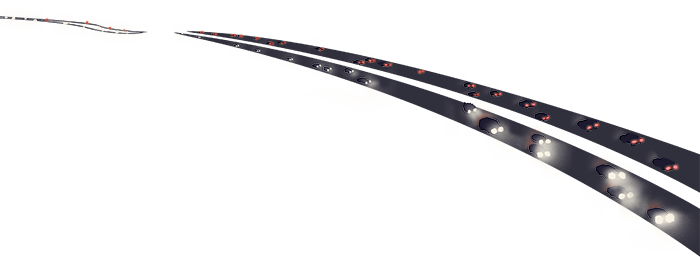
Ecologists map the paths of wild animals navigating a threatened landscape. Brendan Bane joins the hunt. Illustrated by Alexandra Munters and Rebecca Jabs.
Tanya Diamond and Ahíga Snyder stand under a California freeway. Cars pass above their heads, but another busy road runs below their feet. Paw prints mottle the muddy underpass and form interweaving tracks of varying shapes and sizes. Snyder, wearing an orange traffic vest and a beaming smile, points to the prints and says, “Highway!”
Diamond and Snyder are animal trackers. The prints belong to bobcats, coyotes, ground squirrels, raccoons, and sometimes mountain lions. The tracks stretch just a few feet, fading where the sunlight hardened the soil before it could steal an impression. But if they continued, the prints would reveal what Diamond, an ecologist, and Snyder, a wildlife researcher, are hunting for: a series of animal thoroughfares winding through 7,400 acres of farm fields, grasslands, and lightly developed countryside known as Coyote Valley.
Nestled between two mountain ranges just south of San Jose and Silicon Valley’s frantic commerce, Coyote Valley is cherished by many as a nature escape. In 1868 naturalist John Muir described the valley’s landscape as “fairly drenched in sunshine,” its air as “quivering with the songs of the meadowlarks,” and its hills “so covered with flowers that they seemed to be painted.” Wildflowers speckle the valley today. But on several occasions in the last few decades, much of what Muir observed was nearly paved over.
Starting in the 1980s, companies tried to build houses, corporate campuses, and other developments in Coyote Valley. Each proposal acted as a pulse in a pool, inspiring waves of scientists to study the valley’s wildlife. Past researchers documented which creatures live in and move through the landscape. But until Diamond and Snyder, no one had tried to show how they move through the valley.
Today, the duo races to trace the paths animals use to move along creeks, around buildings, and under or over the region’s economic arteries: busy roads. As new buildings crop up, the team rushes to identify which areas warrant protection. They’ll use every tool in their kit, from hidden cameras to genetic clues deposited in poop, to find out how creatures cross Coyote Valley—and, if possible, to make their journeys less perilous.
 |
| Illustration: Rebecca Jabs |
Valley girl
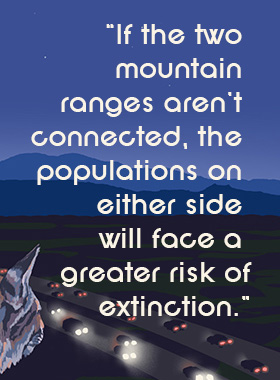
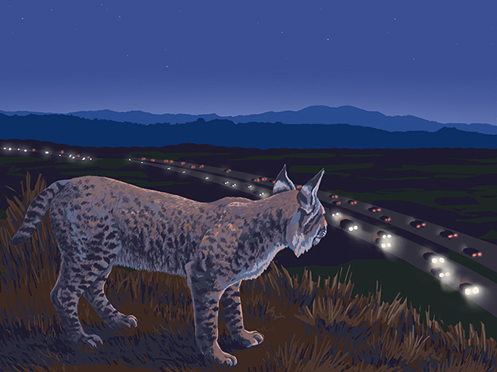
It’s nighttime in the valley. A young female bobcat is on the prowl for new territory and mates. She descends a grassy hill into a dense strip of oak woodland. Beyond the edge of the trees, the valley spreads out below.
In the distance, the foothills of the Santa Cruz Mountains begin low and rise to conceal the Pacific Ocean. Behind the bobcat, the grassy hills climb to blend into the Diablo Range, where herds of Tule elk roam during the day. Between the two ranges, a thin gray structure seems to stretch endlessly from left to right.
Large objects carrying blinding lights quickly glide along the structure. They produce loud gusts easily heard from a mile away. Despite the commotion, the bobcat presses on toward Highway 101.
From east to west, Coyote Valley is transected by three roads: Highway 101, Monterey Highway, and Santa Teresa Boulevard. To move from one mountain range to the other, large mammals must pass by these roads. Highway 101 carries the most traffic, but it’s easier to cross than the others. The historical California highway is peppered with bridges and culverts—drainage tunnels that dip below the road’s surface—which provide safe passage to animals that can find them. In contrast, cement medians and fewer corridors make Monterey Highway nearly impermeable. Indeed, this road—a four-lane speedway through much of Coyote Valley—has just one underpass along its roughly 20-mile route.
The bobcat comes upon her first corridor: a wide underpass beneath Highway 101, where a small creek runs between two wooded trails. Bustling traffic from above drowns out the soft chorus of chirping frogs behind her. An occasional bat squeak pierces the cacophony.
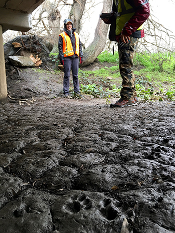 |
| Photo: Brendan Bane |
| Researchers Tanya Diamond (left) and Ahíga Snyder at a wildlife corridor beneath Highway 101. |
|
With no predators in sight, she stops to lap from the creek. But someone is watching. A few yards ahead, a red light flickers, and one of Diamond and Snyder’s motion-detecting cameras springs to life. It records her every movement. Tomorrow, the researchers will retrieve the footage and add it to their database.
The bobcat’s stocky back and head are spotted, but her belly and thighs are striped. Because no two sets of bobcat stripes are the same, the team can identify individual cats, just as marine biologists recognize whales by their flukes.
Markings like these help the scientists estimate how many animals of each species move through the valley. So far, for instance, they’ve detected ten individual bobcats—a surprisingly high number for this territory. At the 12 camera stations they monitor, they’ve seen coyotes, deer, turkeys, pigs, ground squirrels, opossums, foxes, raccoons, and skunks use the underpasses hundreds of times.
As the bobcat continues, she’ll trigger other cameras, helping Diamond and Snyder plot points on the animal thoroughfares they’re trying to uncover. Though she and other creatures face a daunting task when they choose to cross Coyote Valley, a single decision in 1983 could have made the feat nearly impossible.
iValley averted
On a spring day 33 years ago, a helicopter landed near the valley’s heart. Three men emerged: a real estate consultant, a business executive, and a CEO. The third man scanned the tall grasses, envisioning steel and glass structures. His name was Steve Jobs.
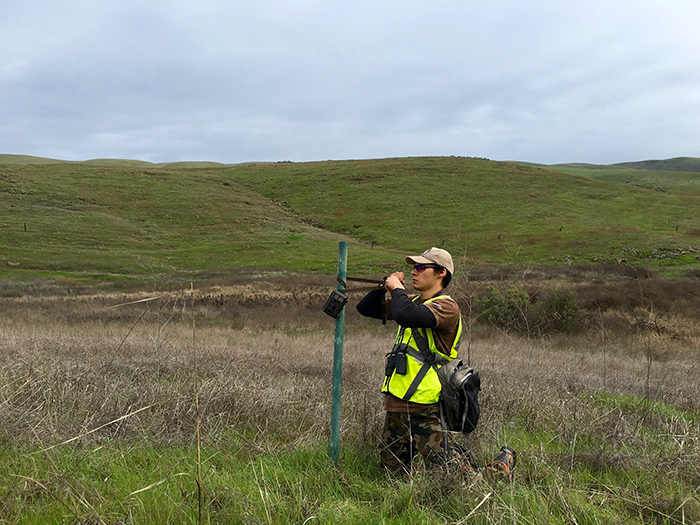 |
| Photo: Brendan Bane |
| Ahíga Snyder adjusts one of the team’s camera stations in Coyote Valley. |
|
Apple nearly built its main campus in Coyote Valley. But the economic recession in the 1980s pushed its development plans toward Cupertino, 30 miles northwest. There, what became the world’s most highly valued company claimed about 200 acres.
Coyote Valley would return from the brink of mass development twice more. Cisco Systems proposed a 6.6-million-square-foot campus for 20,000 employees in 1999. But the company’s plans floundered when the tech bubble burst in 2001. Five years later, the Dahlin Group, a city development company, planned a town of 25,000 homes, complete with a bus and road system. When the group released its first environmental impact report in 2008, hundreds of critics questioned the study. Among them was Tanya Diamond.
“To me it was a huge conservation opportunity,” says Diamond, whose advisor at San Jose State University told her to stay away from the kerfuffle and focus on her thesis. Diamond was studying the valley’s American badgers, now a species of special concern in California, and how they moved from one burrow to the next. She slipped out—against her advisor’s wishes—to add her findings to the report’s critique. “Why write about badgers and wildlife when I can actually go do something about it?” she recalls thinking.
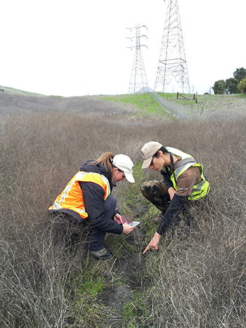 |
| Photo: Brendan Bane |
Tanya Diamond (left) and Ahíga Snyder examine tracks along a heavily traveled animal pathway. |
|
Public opinion won out later that year when the Dahlin Group abandoned its plans, referencing high costs and numerous delays. The threat of large-scale development in Coyote Valley has since petered out. In 2010, the Santa Clara Valley Open Space Authority purchased 348 acres of the valley floor from a group of investors for $3.48 million. They opened the Coyote Valley Open Space Preserve to the public in June 2015.
Conservation groups are poised to snatch up new plots of land as they become available and when funds allow. But businesses can do the same; much of the valley is zoned for light industrial use. Today, Coyote Valley is lightly stamped by development—a few housing tracts, a high school, a community college—and new buildings could crop up at any moment. As people cross paths with wild animals more often, conflict can arise.
Path of least cost
Driving south on Highway 101, Diamond and Snyder scan the shoulder for signs of death. Maps and camera equipment are strewn about their car; dried mud cakes the floor.
Diamond holds up a map. She traces her finger from San Francisco south to where we’re driving, following a gray streak of development that fades only when it meets the brown and green valley. “From the San Francisco Delta all the way down,” says Diamond, “it’s all been completely paved city after city. This is the first space for animals to move from the west coast into the east ranges.” If the gray march of buildings extends through the valley, she says, animals could be stonewalled into isolated ranges.
Diamond spots something on the side of the road. Snyder exits to circle back, parks, and waits for a break in traffic before stepping onto the shoulder. He walks ahead and kneels beside a coyote’s mangled body.
“There’s a culvert just up the way,” Snyder says, looking a mile up the road where a concrete box runs beneath the highway. “I wonder why he didn’t just go there.”
Not all corridors are useful. Some are too dark or small for animals to feel comfortable using them. Others are simply in the wrong place. The best corridors, Diamond says, should fall near the “path of least cost.” That, says Diamond, “is the easiest way for an animal to move through a habitat. If you and I were to go for an easy hike, for example, we would want to follow the lightest trail to get to where we were going.” Animals choose their paths similarly, she says. But in Coyote Valley, all paths eventually lead to the highways.
Animal bodies that repeatedly pile up in the same place, forming what Diamond calls roadkill “hotspots,” suggest many animals travel along the same path toward the highway. Hotspots indicate where future corridors of safe passage should go, says Diamond.
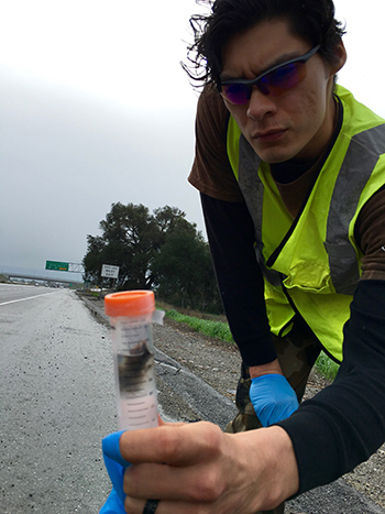 |
| Photo: Brendan Bane |
Ahíga Snyder holds a vial with a flesh sample from a coyote carcass along Highway 101. |
|
Back on 101, Snyder reaches a gloved hand into the coyote carcass to pinch a sample of loose skin. With a snip of his scissors, he frees a chunk of flesh and drops it into a clear vial. Tomorrow he’ll mail the chunk, along with samples of scat he’s collected elsewhere, to graduate student Morgan Gray at UC Berkeley. Gray is helping the pair understand whether animal populations in Coyote Valley are genetically linked.
Clues from poo
“It’s pretty gross,” says Gray, whose lab desk holds dozens of tubes filled with feces, flesh, and animal hair. When their project began, Diamond and Snyder mailed every scat sample they could find to Gray, which proved problematic. “Some of the samples were really dry and the DNA inside had degraded,” she says. “So now they send me the freshest, moistest poop they can find.”
By looking at the animals’ DNA, Gray can tell if communities are meeting and breeding or if they’re isolated behind barriers. She does this by testing “pairwise divergence.” The test refers to taking two copies of the same gene—one from each animal group—and looking for differences between them. For this project, Gray is comparing a population of ground squirrels on the western side of Highway 101 with squirrels from the eastern side.
If ground squirrels from the west are traveling to meet eastern companions, Gray would expect their genes to look similar. But if none of the squirrels could move between the two groups, each set of genes would change over time and eventually appear different. Large differences could be a sign of isolation, she says, which can be dangerous.
“If the two mountain ranges aren’t connected,” says Gray, “the populations on either side will face a greater risk of extinction.”
To keep a population healthy, its gene pool must stay diverse. Genetic variety boosts a group’s chances of surviving challenges like sudden environmental shifts or sweeping diseases. When young animals migrate into new territories, they bring new genes that increase the pool’s diversity. If populations are isolated, that flow of new genetic material is strangled and the groups become less resilient.
Another risk of isolation is inbreeding. When animals have only their close relatives as mates, faulty genes—which are otherwise muted in genetic shuffles when unrelated animals breed—can crop up and cause harm. Veronica Yovovich, a UC Santa Cruz ecologist who studies mountain lions and isn’t involved in the project, warns that developing Coyote Valley could doom the large cats to inbreeding.
|
Brendan Bane joins a pair of field biologists who track the movements of mountain lions and other animals across fragmented landscapes north of Santa Cruz. Click on image to play. |
“For mountain lions,” she says, “Coyote Valley is the last corridor connecting the Santa Cruz Mountains to the rest of California.” Yovovich draws a comparison to pumas in Florida. That population was twice as large as the Santa Cruz Mountains group, and thus assumed to be more genetically robust. But Florida’s pumas became isolated by hunting and development. Today, many have heart defects, deformed sperm, and kinked tails, all symptoms of inbreeding. Coyote Valley’s passageway, Yovovich says, helps the cats of central California’s coastal range avoid this fate—for now.
A path appears
In their Los Gatos apartment, Diamond and Snyder load their latest pictures and videos into their computers. The two met when Diamond began advertising on university campuses for a research partner. She had realized that by doing solo searches for dangerous animals beneath freeway underpasses, she risked removing herself from the gene pool. Snyder was the first to respond to her ad. Today, they’re engaged.
When they review their footage, the two take to separate rooms. Snyder listens to heavy metal music while ticking off animal sightings. Diamond, in the next room, needs quiet. When they’re through, they swap files to check each other’s records.
Their screens display movies in glowing night vision. In one clip, a raccoon wades through a flooded underpass, fishing with its dexterous hands to find underwater morsels. In another, deer scramble beneath a chainlink fence to reach a cement corridor beneath Highway 101. En masse, the clips confirm that animals of all stripes use these underpasses to move across the valley.
As they compiled their sightings over the past year, Diamond and Snyder noticed a pathway emerging. They found that animals tend to cross the valley in the shape of a left-leaning “n,” with its apex settling at the only corridor on Monterey Highway: Coyote Valley’s most dangerous road. Animals move in both directions across the valley. From the west, they cross Santa Teresa Boulevard, which doesn’t see much traffic, toward the Monterey Highway corridor. If they successfully cross, they skirt down through the various corridors of Highway 101 to reach the Diablo Range.
|
Infographic: Brendan Bane |
Motion-activated cameras reveal the paths animals move through Coyote Valley, shown in green lines. Click on the red markers for images, videos, and details from each station, then click on the lead image to see larger versions. All images courtesy of Tanya Diamond and Ahíga Snyder. |
|
Though animals do use the Monterey Highway corridor, it’s not perfect. Walk west through its tunnel and you’ll stumble onto a pile of concrete slabs, which were likely left after construction. The slabs jumble together like Jenga pieces, forming cracks where hoofed animals can get caught and fall.
Snyder says deer come through the corridor, see the slabs, and turn around to find another way. The team has documented many cases of ground squirrels, raccoons, and coyotes that died trying to cross the road nearby. The animals become trapped when they reach the tall median and turn back into oncoming traffic.
By scouring footage, the team discovered Coyote Valley’s surplus of bobcats. Because male bobcats have home ranges that span more than three square miles, with females claiming territories half that size, the scientists estimated that the valley could accommodate two bobcats. Instead, they’ve seen ten. Some may be nomads, Diamond says. One bobcat pair produced two kittens in October 2015.
In the northeastern section of the valley, recordings showed a pair of coyotes frequenting a creekside underpass on Santa Teresa Boulevard. Soon after, two coyote puppies started scampering around the same area. The team has found juvenile wildlife at more than half of the camera stations. Puppies and kittens are a strong sign, says Diamond, that the surrounding habitat is healthy and worth protecting.
Diamond and Snyder are already sharing their findings with government agencies, conservation organizations, and transportation departments. The results, says Yovovich, will help developers, city planners, and community members decide where and where not to build.
“We can’t lock up all the habitat, throw away the key, and preserve everything,” says Yovovich. “We need landscapes to have dual purposes, and we need to be sensitive to the natural environment. We need to understand how animals move around the landscape so that when we build, we can be mindful of protecting spaces that maintain habitat connectivity. We need to make sure we’re being responsible.”
© 2016 Brendan Bane / UC Santa Cruz Science Communication Program
Top
Biographies
 Brendan Bane Brendan Bane
B.S. (ecology and evolutionary biology) University of California, Santa Cruz
Internship: American Geophysical Union (Washington D.C.)
Majestic trees, beautiful birds, graceful whales—these inspire many childhood biology buffs. My muses were hairy tarantulas. On most days I entered their world by pressing my nose against terrarium glass or into the pages of natural history books. I later followed my passion to the cloud forests of Costa Rica, where I studied how tarantulas communicate their romantic intentions. (Basically, they twerk.)
Though I loved tromping through forests and spying on tarantulas in their roadside burrows, my greatest thrill did not come from the field or laboratory. Instead, I was happiest onstage, bringing my audience face to fang with spiders through visual storytelling. Now, through science reporting, I will immerse my readers in the lives of all flora and fauna, whether wondrous or weird.
Brendan Bane’s website
. . . . . . . . . . . . . . . . . . . . . . . . . . . . . . . . . . . . . . . . . . . . . . . . . . .
 Alexandra Munters Alexandra Munters
B.A. (philosophy) St. John’s College
M.S. (wildlife ecology) Texas State University
Internships: Monterey Audubon Society, Humboldt State University
Alexandra is an ecologist and illustrator seeking to savor and share the balm and beauty of the earth through art and science education. Since earning her degrees she has been primarily focused on bird research and conservation. Finding that illustrating the subjects of her research helped her to better understand and connect with them, she began sharing her illustrations, eventually deciding to professionally incorporate art into her message of stewardship and appreciation for the natural world. She is passionate about finding creative and interdisciplinary ways to communicate the findings of sound science and plans to one day illustrate all the birds of the world. At Humboldt State University, she will work with Dr. Mark Colwell to illustrate a book titled The Population Ecology and Conservation of Charadrius Plovers.
Alexandra Munters’s website
. . . . . . . . . . . . . . . . . . . . . . . . . . . . . . . . . . . . . . . . . . . . . . . . . . .
 Rebecca Jabs Rebecca Jabs
B.A. (art education) Wisconsin Lutheran College, Milwaukee
Internships: Smithsonian Institution, Collins Marsh Nature Center (Wisconsin)
Rebecca is a natural science illustrator and artist based in Wisconsin. She spent eight years as an art teacher before entering the Science Illustration Program at CSUMB. She looks forward to an internship at the Smithsonian’s Entomology Lab in Washington D.C., followed by a second placement at the newly constructed nature center of Collins Marsh in Reedsville, Wisconsin.
Rebecca Jabs’s website
Top |